Showing posts with label Antonine Wall. Show all posts

Sunday, 8 March 2020

Glasgow to Culross - Part 3. Falkirk to Culross

At the end of last year I spent a few weekends running The Fife Pilgrim Way, a new long distance footpath from Culross to St Andrews. I enjoyed the challenge, particularly as it took me away from running my usual jogging routes in Glasgow again and again. So this year, to explore the rest of Central Scotland I plan to complete my run across Scotland, from the Ayrshire coast to the Fife coast at St Andrews.

This middle section takes me from the River Clyde in Glasgow to Culross on the banks of the River Forth.

Falkirk to Culross


Glasgow to Culross - Part 3 - Falkirk to Culross


Falkirk to Grangemouth


Falkirk is a more historically important part of Scotland than you might imagine if, like me, you only ever come here on away days to watch lower league football. 2000 years ago the eastern end of the Antonine Wall passed through the spot where the town now sits, the northernmost extent of the Roman Empire in Britain. However, after a couple of decades the Romans decided that there was nothing here for them and they retreated back to Hadrian's Wall.

A millennium later The Battle of Falkirk in 1298 was a major defeat for the Scottish forces led by William Wallace, when Edward Longshanks came north again and this time hammered the Scots.

In the 1700s Falkirk was home to one of the largest cattle markets in Scotland, but 100 years later it was as an industrial town that it grew in importance. At the junction of the Forth and Clyde Canal and the Union Canal, its good transport links led to the development of many industries, particularly iron foundries, like the Carron Ironworks which used local iron ore and coke derived from local coal. By 1814 this was the largest ironworks in Europe, employing 2000 people. It had produced James Watt's first steam engine, and cannons deployed by Wellington at the Battle of Waterloo. This created great growth in the town, but by the 20th century, the decline in the local industries led to a decline in the town.

I ran here from Glasgow along the canal, so decided to follow the canal to its end when I arrived back in town today. After passing the Falkirk Wheel which connects it to the Union Canal, the Forth and Clyde Canal heads towards its eastern sea lock at Grangemouth and the River Carron.

Callendar House, Falkirk
Callendar Lake, in Callendar Park, Falkirk
Arriving back at Falkirk High train station I ran down through Callendar Park as a fine winter's morning was dawning. Callendar House here dates back to the 14th century, but was re-modelled in the style of a French chateau in the 19th century. A ditch of the Antonine Wall cuts through the grounds near to the house.  

Having initially headed off on a wild goose chase up the verge of a B-Road that didn't have a pavement, I eventually got back onto safer ground near Falkirk Stadium. To me this seems brand new, but Falkirk Football Club have been playing here now since 2004, when Brockville, their home since 1885, was demolished and the land sold. To be honest, if it hadn't been demolished, it looked like it was going to fall down by then, after decades of neglect. Falkirk where denied promotion to the SPL in 2003 due to their stadium not meeting the top league's (ever changing) criteria, which forced the move. Nine million pounds from Morrisons, who built a supermarket on the land, probably helped sweeten the move (not sure how reliable this figure is, but if Wikipedia says it, it must be true). 

Falkirk Stadium early in the morning
The area between Falkirk Stadium and the River Carron was redeveloped as part of the Forth and Clyde Canal regeneration. When the canal was re-opened in 2001, a new lock into the River Carron had to be devised as the former route of the canal where it entered the river at Grangemouth docks had been obliterated by roads and housing. The new lock was less then ideal at either low or high tide on the River Carron and as part of a project to improve the area a new connection to the River Carron was devised and a park with cafes, walkways and play areas was created. The Helix Park was the end result, its most recognisable feature being the much loved Kelpies

The Kelpies at Falkirk
The 100 foot tall sculptures recall the heavy horses that used to pull barges along the canal, but kelpies are also shape-shifting spirits associated with water in Scottish folk tales. These malevolent creatures would lure you towards them, either in the form of a horse or a young woman. Once you were in their grip you would be pulled to your death below the water. 

The Kelpies were created by Glasgow based sculptor Andy Scott. His other familiar works include the John Greig statue at Ibrox, the heavy horse near to Easterhouse by the side of the M8 that welcomes you into Glasgow, the four armed woman (Arria) near the M80 at Cumbernauld and the new sculpture of Charles Rennie Mackintosh sitting atop one of his distinctive chairs in Anderston. 

Lock gate between the Kelpies marina and the River Carron
The Kelpies
As you can see from the picture of the lock gate above at the River Carron, at low tide on the river the drop is too great. However at high tide, there is little space to allow any boats to pass under the M9 and other bridges on the River Carron. A short stretch of canal was cut parallel to the river to take boats further downstream to avoid this problem. Along this stretch The Charlotte Dundas Heritage Trail tells the story of the Grangemouth boatyard, where the early steamboat Charlotte Dundas was built. 

Kelpies seen from the new stretch of canal after it passes under the M9 motorway

Grangemouth to Kincardine


Grangemouth grew up around the docks that were here, but now the main employer is the Ineos refinery and petrochemical plant. The chimneys, cooling towers and gas flares here, usually shrouded in steam, are a distinctive feature of this part of the world, visible from miles around. I was talking once to a guide at Culross, the historic and scenic village across the River Forth from Grangemouth, about what he thought of the dystopian vision across the water. He made me look at it anew, as he delighted in its lights and steam, showing that the area could still provide skilled jobs for local people, and that we weren't stuck in the past here, becoming a heritage curio.

Grangemouth refinery 
He is right, but this type of industry is itself now becoming something of the past, like the coal mines that once were seen all across the central belt. They have all now completely vanished. In a world of climate change we need to move away from relying on fossil fuels, and create new technologies and industries. Government investment in order for us to get from where we are now, to where we need to be still seems to be pie in the sky despite the evidence of our own eyes that climate change is having an effect on our world already.

River Carron, west of Grangemouth
As the canal heads down towards the Grangemouth refinery, I headed north across the River Carron and on towards the Kincardine Bridge. This area of land has tidal wetlands down by the river and can be home to flocks of birds, like the many geese that I scared into the air today as I ran through here. Two horses gave me a disinterested glance, briefly looking like a Kelpies tribute act.

/
Kelpies or horses
Skinflats has got to be one of the best/worst names for a village in Scotland. Anyone who has driven across the Kincardine Bridge will know the name from the road signs pointing it out before you cross the bridge. Purely to satisfy my curiosity I took a short detour through the village before following the old paths down in the direction of the River Forth. Formerly a mining village, the pits have all now gone. However about 300 people still live here, amongst farmland and wetlands, with views across to Grangemouth. By the waterfront much work has recently been undertaken on what is now an RSPB reserve to recreate saline lagoons. This makes a perfect environment for certain terns, avocets and plovers and is a spot where numerous rare waterbirds can be found.  

Skinflats
Grangemouth seen behind an old farm building at Skinflats
Path towards the River Forth
Not wanting to get too bogged down in the mud I headed northwards towards the bridges again, zig-zagging along various paths. As Grangemouth's chimneys faded into the distance, the tower of Longannet Power Station on the other side of the river came into view. Longannet was the last coal-fired power station in Scotland. When it opened in 1970 it was the largest coal-fired power station in Europe, and it operated until 2016. The site has now been ear-marked to become a train manufacturing factory, which is expected to open in 2023.

Grangemouth
Looking across farms and the River Forth towards Longannet
Longannet and Grangemouth on either sides of the River Forth
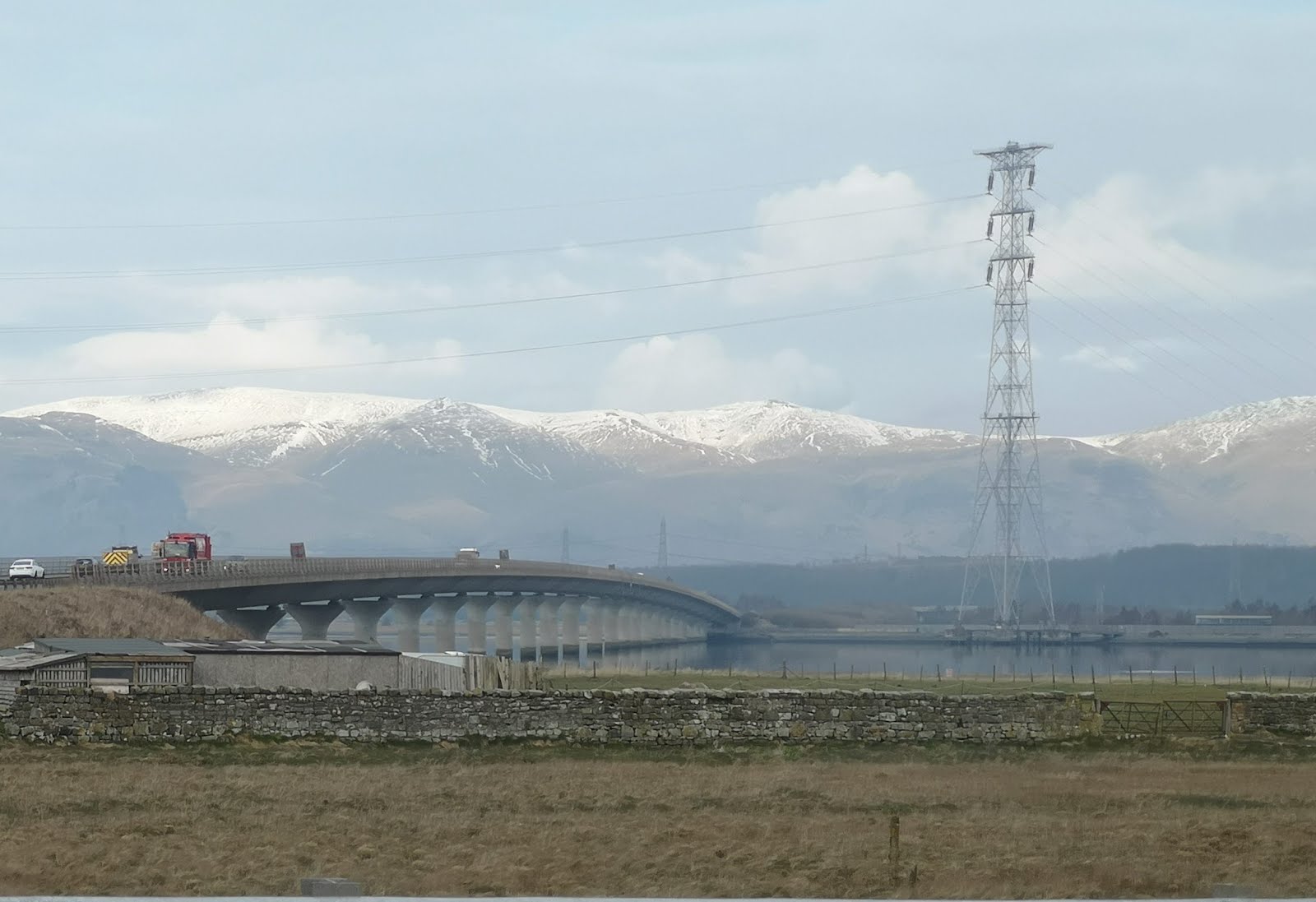
Two bridges now cross the River Forth at Kincardine. The original Kincardine Bridge was opened in 1936, thirty years before the Forth Road Bridge at Queensferry. A central pivoting section could be swung round to allow ships to pass up river to the port at Alloa, but this has not functioned since 1988. Due to increased traffic and congestion, a new bridge across the river was built here, and opened in 2008. The Clackmannanshire Bridge is in the curious position of the north approaches being in Clackmannanshire, the span of the bridge in Fife, and the southern approaches being in Falkirk council area. 
Clackmanannshire Bridge with snow-topped Ochil Hills beyond, March 2020
Central pontoon on the Kincardine Bridge, looking downriver
Kincardine Bridge over the River Forth

Kincardine to Culross


After running across the bridge I had a quick stoat about Kincardine, basically because it is a town that I often drive past but have never stopped in. It has a surprisingly old feel to it, despite being sliced up by a century of major roads being cut through the town. The town itself dates back 500 years and was at one time a fairly substantial port, with ferries frequently used by drovers taking their cattle to market in Falkirk. At low tide the old jetty and the skeletons of some old wooden boats were visible in the mud. 

Kincardine Bridge from the slipway in Kincardine
The rotting hulls of old wooden boats in the mud at Kincartdine
As I wanted to visit the old Tulliallan Kirkyard I popped into Marco's Kitchen, a cafe at the bottom of Kirk Street, where the key and guidebook to the graveyard are kept. Tulliallan Old Parish Church was built in 1675 and replaced in 1832 by a new church on another site, leaving the old kirkyard and church building like a time capsule. The local history group have made a great job of restoring the gravestones and maintaining the churchyard and their website is a treasure trove of information on the beautifully carved gravestones to be found here. Many of them have emblems of the occupation of the deceased carved on the stone, everything from painters and coal miners to farriers, sailors, tailors and foresters. 

Marco's Kitchen, Kincardine

Old Tulliallan kirkyard
From 1767 a gravestone with an anchor, a weaver's shuttle, carding comb and stretchers, an hourglass, crossed bones and skull
A woodcutter chopping down a tree, 1787, with the motto "As the tree falls so must it ly."
Shield with pendants, lances and crossed flags. "Erected in memory of William Greig. Died 16th November 1805 aged 32." (A soldier/sailor it is believed that he may have died from injuries sustained at the Battle of Trafalgar, 21st Oct 1805)
Having remembered to drop off the key again, I was able to join the Fife Coastal Path and run along the last part of today's route to Culross while avoiding the roads. The path goes past Longannet Power Station just outside Kincardine before winding its way to Culross. 

Fife Coastal Path at Kincardine
Longannet Power Station
Coming into Culross means that I have now joined up to my route from a couple of months ago, when I started at Culross, to run towards St Andrews. As it was such a lovely day I wandered out to the end of the pier at Culross, facing towards Bo'ness on the other side of the Forth. "Do not throw stone" the message reads to prevent people chucking bits of the old pier into the river. The end of the pier at Culross looks across the River Forth to Bo'ness where my great-great-great-great-great grandfather was born in 1751. Three generations of nautical trades later my great-great granny, Agnes Donaldson, headed west and married a stonemason in Rothesay.

Culross pier
Before lunch in one of the town's cafes I wandered back up the hill to Culross Abbey. In the abbey the Bruce family burial vault contains the ostentatious monument to Sir George Bruce, who died in 1625, the former resident of Culross Palace at the bottom of the hill. This includes marble carvings of his eight children piously praying by his tomb. On a wall in the tomb is a curious plaque to another Bruce. It records that the heart of Lord Edward, Lord Bruce of Kinloss, has been deposited here. He died fighting "a bloody duel" in 1613 with the Earl of Dorset, near Bergen in Holland, "in which country the combatants had repaired, the one from England, the other from Paris, for the determined purpose of deciding their quarrel with the sword."

Memorial to Edward, Lord Bruce of Kinloss
Monument to Sir George Bruce, in Culross
So I have now enjoyed running from Glasgow to Culross, and from Culross to St Andrews. Now I think it is time to turn west, and head from Glasgow to the Ayrshire coast

Monday, 2 March 2020

Glasgow to Culross - Part 2. Kirkintilloch to Falkirk

At the end of last year I spent a few weekends running The Fife Pilgrim Way, a new long distance footpath from Culross to St Andrews. I enjoyed the challenge, particularly as it took me away from running my usual jogging routes again and again. So this year, to explore the rest of Central Scotland I plan to complete my run across Scotland, from the Ayrshire coast to the Fife coast at St Andrews.

This middle section takes me from the River Clyde in Glasgow to Culross on the banks of the River Forth.

Glasgow to Culross - Part 2 - Kirkintilloch to Falkirk


Last weekend I ran from Glasgow to Kirkintilloch along the tow path of the Forth and Clyde Canal. This week I continued upon my very literal cross country run, from Kirkintilloch to Falkirk. From Glasgow I hopped on the train at Queen Street, which takes about 10 minutes to get to Lenzie, and then jogged down to the centre of Kirkintilloch to rejoin the canal.

St Mary's Parish Church by the canal, Kirkintilloch

Kirkintilloch to Twechar


Soon leaving Kirkintilloch, the canal meanders through the countryside all the way to the River Carron at Grangemouth, just beyond Falkirk. The canal just out of Kirkintilloch is accompanied by the River Kelvin, which lies just to the north for about the next 5 miles. Beyond that can be seen the Campsies, a gently rolling range of hills that was formed from lava flows 300 million yeas ago. The Campsies have long been an easily reached rural escape for the people of Glasgow, and was where I first went camping with my school friends. The wee dusting of snow today is a hint of the Campsie Fells place in Scottish skiing history, where William Naismith made the first ever skiing expedition in Scotland, in 1890.

The River Kelvin and the Campsies, viewed from the Forth and Clyde Canal outside Kirkintilloch
The Forth and Clyde Canal was opened in 1790. It became a popular route for sea-going craft to get coast-to-coast, avoiding the treacherous seas around the north of Scotland. It was also used to transport cargo (woven cloth, timber, coal, pig iron, sandstone, and agricultural produce) across the country, and to and from sea ports, at a time when the roads were poor. With the arrival of the railways in the 1830s, and then over time improved road transport, the canal soon became an uneconomic way to travel.

Especially in Glasgow, there is still lots of evidence of the former industrial buildings that huddled by the canal, but coming along this way it is all now open countryside, a few former lock-keepers cottages and derelict buildings hinting at the former activity on the canal. The canal was closed to traffic in 1962 and when I used to live overlooking it in Maryhill in the 1970s it had basically become an open refuse tip. After much work it was re-opened to barges and boats in 2001 but there are ongoing battles still to maintain the funding to keep it open.

Derelict building beside the canal
Reaching Twechar I veered off to the right to take a short diversion to the local Roman fort. Twechar was a mining village. The first substantial pits here were dug in 1860 and mining continued until 1968. For at least 50 years much of the coal was transported away via the canal.

The Antonine Wall, marking the northernmost extent of the Roman Empire in Britain runs across Scotland from Old Kilpatrick in the west to Bo'ness in the east, and therefore runs alongside the canal for much of its route. Constructed around 142AD it was built, occupied and then abandoned by the Romans over a period of just 20 years. To the north of the wall was dug a ditch, 5 metres deep in parts, then the wall constructed with layers of turf on a stone foundation, with some possible wooden palisades on top. Along the length of the wall were built 17 major forts, plus additional "fortlets" which accommodated about 7000 men. South of the wall ran a military way, a road allowing soldiers and supplies to move swiftly along the wall. 

Bar Hill Fort at Twechar is the highest fort on the Antonine Wall, with impressive views east and west along the line of the wall. Although it is hard to imagine today the impact the arrival of the Roman garrison here had on the people living hereabouts, the buildings would have been unlike anything the locals had ever seen before. The headquarters building here, the principia, had rows of stone pillars and iron window grilles housing glass windows. These can all be seen at the Hunterian Museum in Glasgow. 

The principia at Bar Hill Fort, Twechar

Columns taken from Bar Hill Fort, now on display in Glasgow
The soldiers manning the fort at Bar Hill were initially Baetasian soldiers from Rhineland, and then later Hamian archers from western Syria. Among some of the archaeological finds were discovered north African style pottery, and it may be that some African soldiers had been recruited to the Baetasian ranks during their time fighting the Mauretanian War in modern day Morocco, before being transferred to modern day Twechar.

Gravestone of Salamanes
The gravestone above, now in the Hunterian Museum, was from Bar Hill. It is dedicated by a father to his fifteen year old son, Salamanes, a Semitic name, revealing the middle Eastern origins of this family. It is thought that his father was a merchant who had traveled here from his homeland to a civilian settlement adjoining the fort. Below is part of a gravestone from Bar Hill, a reclining man with what looks like a dog. 

Roman gravestone
The bath house at Bar Hill Fort is shown below, where soldiers would relax and play board games. Other objects from Bar Hill Fort that can be seen at The Hunterian are beautiful leather shoes from a man, woman and child (400 leather shoes have been found here on excavations), and a wine barrel with a bung hole in the side found in a rubbish pit, with its owner Januarius' name scrawled on the side. 

Bar Hill Fort bathouse

Roman shoes found at Bar Hill
Old wine barrel found in a rubbish pit at Bar Hill Fort
On an increasingly blustery February morning I imagined those shivering Baetasians or Hamians waking up for another day on patrol in this remote outpost of the Roman Empire as I jogged on east along the wall. Before getting back to the canal I followed a path from here that leads to Castle Hill, a rocky lump that was once home to an Iron Age fort 500-700 years before the Romans arrived. Getting back on track, I headed along the route of the Military Way, which lies just south of the Antonine Wall, and then via forestry roads to a path signposted for Auchinstarry. 

The Military Way leaving Bar Hill Fort, the Roman road behind their wall
Path down to Auchinstarry

Twechar to Bonnybridge


Getting back on the canal path I arrived at Auchinstarry which lies between Croy and Kilsyth. It is now home to a marina but it is also where Auchinstarry Quarry is found, a popular rock climbing spot. Just east from here on the canal was previously found Craigmarloch Basin. Now overgrown with weeds it is hard to spot, but from the 1890s until 1939 this was the terminus for pleasure cruises from Port Dundas in Glasgow. Steam ships such as the Fairy Queen and the Gipsy Queen. A tearoom here catered for the day-trippers, who could visit the putting green, play in the swingpark or take a picnic up the short walk to Croy Hill behind the tearoom. Nothing now remains, although plans are being submitted to try to restore the nearby canal stables, which date back to 1820.

Boats at Auchinstarry Marina
Pleasure boats at Craigmarloch Basin on the canal 100 years ago
I took a short diversion off to the left here to follow the River Kelvin to its source near the hamlet of Kelvinhead, 22 miles away from where the river joins the Clyde in Glasgow. Here it is little more than a babbling burn. I have no proof of the fact, but the Kelvinhead local community website claims that the village was the place where the first potatoes were grown in Scotland, the beginning of a long love affair between Scotland and the starchy tuber. 

Shortly after the Kelvin veers away from the canal we come to something that hasn't been passed on the canal since leaving Maryhill in Glasgow; a lock gate. The flat summit of the canal comes to an end here and we start to slowly descend towards Falkirk. The former lock-keeper's cottage, and stable block and inn across the canal have been converted here into private houses. 

The mighty River Kelvin near to its source, at Kelvinhead

Wyndford lock-keeper's cottage
Canal bird spotting. Cormorant, traffic cone, oyster-catchers and gulls.

Bonnybridge to Falkirk


Continuing east along the canal path you soon go under the M80 motorway near to the Castlecary arches, and with the handsomely named Bonny Water to the north of the canal instead of the River  Kelvin, we soon come into Bonnybridge. I had never been to Bonnybridge before, and unfortunately only knew it as the UFO-spotting capital of Scotland. Also I cannot help but pronounce its name in the style of "Stoneybridge" from the TV show Absolutely. A village has existed near the river crossing here for several centuries, but it was in the 19th century that it increased in size with people coming to work in the sawmill, paper mill and iron foundries that were being established.

In 1820 the last armed uprising on British soil took place, a year after the Peterloo Massacre in Manchester. A week of strikes and unrest led to workers marching in Strathaven, and another group marched towards the Carron Ironworks in Falkirk, intent on seizing weapons. This group , armed with a handful of muskets and pistols and homemade pikes, were led by John Baird, a weaver from Condorrat, and Andrew Hardie a weaver from Townhead in Glasgow. Both men had been soldiers in the recent Napoleonic Wars. On the outskirts of  Bonnybridge this small group of men rested in a field, at a place called Bonnymuir. The radicals had been heavily infiltrated by spies and agents provocateurs and the government forces knew of their plans. At Bonnymuir a detachment of Hussars on horseback attacked them in a sabre charge. Realising that it was a fight they could not win, the Radicals surrendered. Several men were injured and rumours of others being killed circulated widely. The captured Radicals were taken through a tunnel under the Forth and Clyde Canal here and marched to imprisonment in Stirling. The "Battle of Bonnymuir" took place on 5th April 1820, almost exactly 200 years ago.

In the following months 88 people were tried for treason. Many were deported to Australia. James Wilson of Strathaven was executed in August 1820, and upon 8th September 1820 John Baird and Andrew Hardie were executed in Stirling. Hanged and then posthumously beheaded. A small plaque at Stirling Tolbooth, and a monument in Paisley commemorate their deaths.

Radical Pend, Bonnybridge
The passageway, or "pend", that the prisoners were taken through on their way to Stirling Castle was renamed "Radical Pend" in 1981, and a plaque above the arch was unveiled by Winnie Ewing to mark the occasion. It is one of the oldest tunnels under the canal still in use, constructed in 1780. After running through this I tried to find the hillside known as Bonnymuir. Unfortunately I ended up on the wrong side of the railway tracks here and had to take a circuitous route to it, but I got there in the end. It did let me run past some fields filled with Highland coos, and barnacle geese, which was nice.

Memorial stone to the Battle of Bonnymuir
Is this the Radical Dyke?
A memorial stone at the side of the B816 now marks the spot where the "Radicals took cover behind a 5 foot high dry-stane dyke...later known as The Radical Dyke". I wandered into the field trying to find that radical dyke. I don't know if I saw it, or just a pile of stones, but I am glad that Andrew Hardie and John Baird are not forgotten. I have seen James Kelman talk several times, at book launches and the like, and he almost inevitably manages to get the topic of conversation around to our lack of knowledge in this country of our working class radical history. In fact he has previously written a play about these events "Hardie and Baird - The Last Days". It surely is due a revival on the bicentenary of this Radical Rising, Scottish Uprising or Radical War. The events of that year go by many names but I would hope to see them investigated more fully and taught more widely.

Once I had found Bonnymuir I was so far away from the canal that I finished my run into Falkirk along the John Muir Way. This path goes from Helensburgh to Dunbar, John Muir's birthplace, and their website has lots of useful information on the various attractions along the route.

Finishing my day on the Antonine Wall I passed through Rough Castle. Little remains above ground from the excavations from the last century of the fort, but the rampart and ditch here are more obvious that at other parts of the wall. 

Antonine Wall at Rough Castle, near Bonnybridge

The site of Rough Castle, little of it remains at the site
Continuing along the path eastwards out of Rough Castle, after a short distance I arrived at the mighty feat of engineering known as the Falkirk Wheel. The world's only rotating boat lift takes vessels between the Forth and Clyde Canal and the Union Canal. Due to a maintenance issue I understand that the Union Canal is not navigable from here to Edinburgh at present, but plans are in place to repair it this year. In the meantime you can still take short boat trips up and down the Falkirk Wheel if you fancy.

The Union Canal where it connects to the Falkirk Wheel

Falkirk Wheel

Falkirk Wheel and visitor centre, viewed from the locks that lead to the Forth and Clyde canal
I am delighted that the canal network across Scotland has been re-opened, and provides green corridors for people to enjoy. At present it is a struggle to finance the necessary maintenance to keep the canal safe and navigable, but I think that it is of benefit to the common good and worth preserving. Maybe I am just biased because until I was 11 years old my bedroom window, looked down into the canal and Maryhill Road. Running along it today I enjoyed learning about the people that have worked, played, fought and rebelled along this quiet strip of greenery, and I have almost made it from Glasgow to the east coast now without stepping on tarmac for very long, or dodging any cars. Next for me is to find a route from Falkirk to Culross.

Antonine Wall at Watling Lodge, Falkirk
After a roll and square slice and a mug of coffee at the Falkirk Wheel visitor centre I jogged on to Falkirk High train station, passing another impressive bit of Antonine Wall at Watling Lodge, where the deep ditches of the wall are very obvious. One last Roman find to end on. At Bar Hill fort many statues to Silenus were found. He is usually depicted as an older man, a drinking companiion to Bacchus, and sometimes described as the god of drunkenness. It seems that he was a popular character with the soldiers. This wee statue of him below, which can be seen in The Hunterian Museum, describes him as having "an extended middle finger to ward off the evil eye." 

A 2000 year old statue from a Roman fort in Scotland that seems instantly recognisable.