Coast to Coast Part 13. Wemyss Bay to Largs
Almost two years ago I decided to run, in stages,
all across the Central Belt of Scotland. It started out as a way to give myself a change of scene on my longer weekend jogging routes. Eventually I decided to link two of my favourite coastal towns, bringing back memories of childhood holiday destinations. My runs would hopefully take me from Largs on the Ayrshire coast, to St Andrews in Fife.
I followed the Pilgrim's Way footpath from St Andrews to Culross, then came through Falkirk and Kirkintilloch to reach Glasgow. From here my route took me through Paisley to Greenock, Gourock and to Wemyss Bay. By now it was March 2020. The first Covid lockdown stopped me getting to Largs. Today I finally got round to completing my Wemyss Bay to Largs section.
I was about 9 years old when we had a holiday in a static caravan in St Andrews. I remember clambering over the ruins of the cathedral and walking along the long sandy beaches there. However as kids it was the west coast where we usually spent our free time, Helensburgh, Rothesay, Dunoon, Largs and Millport.
 |
Holidaying in St Andrew, 1980s
|
Doon the Watter
Since the launch of Henry Bell's, Port Glasgow built, PS Comet steamboat in 1812 trips down the Clyde became affordable to more people. This led to the growth of towns such as Helensburgh, Gourock, Largs, Rothesay, Dunoon and Millport which developed as seaside resorts for day trippers and those taking a holiday from Glasgow.
 |
| 1952 - a steamship gets ready to leave Glasgow for the Ayrshire coast |
Although trips "
doon the watter" for the
Glasgow Fair really belong to the generations before my time, like many Glaswegians as a family our earliest holidays were down to the Ayrshire coast. Aged about 4 or 5 years old I well remember staying in a wee lodge at Butlin's holiday camp in Ayr, now Craig Tara.
 |
| At Butlin's holiday camp in Ayr |
The other early holiday memory I have was staying in a house on Arran with my mum and dad, my brother, my granny, grandad and great-uncle. The seven of us squeezed into my grandad's car for the journey down from Glasgow, me sitting on my mum's knee in the front. This was in the days before wearing seat belts was compulsory in cars. We didn't have a car ourselves but would often get the train, or go for a run with my granny and grandad, to the likes of Helensburgh or Largs.
 |
| Me in the kilt, on the beach in Arran |
As I became active in
Youth CND in the 1980s, my trips out west from Glasgow were usually connected to demonstrations, vigils or marches at the US and British bases on the Clyde and
Holy Loch. A
die-in at the American base on Holy Loch would then be combined with a wee visit to the Dunoon amusements before getting the ferry home. A march to
Faslane was often combined with getting an ice cream cone in Helensburgh afterwards before squeezing into the back of a red Lada that my parents' friend owned, or catching the train back to Glasgow.
 |
| My grandad, aunt, uncle and mum on holiday in Dunoon |
Largs was always my favourite day trip, either with my grandparents, with my parents or later on, with my own children. It is always just nice to be beside the seaside, but especially if it involves a single nougat (pronounced "nugget" of course) from
Nardini's and a couple of hours in the amusement arcades there.
Covid-19
So the end point of my runs across Scotland was to be Largs on the west coast, both for personal nostalgia, and because it is easy to get the train back to Glasgow basically. The ferry from Largs to Millport and Great Cumbrae was to be the grand finale, as I was going to take part in a 10 mile race around the island in mid-May 2020 to finish off. This was my plan in the days before the Covid-19 pandemic brought necessary restrictions on people's movements and activities.
The race was cancelled and I had got all the way from St Andrews to Weymss Bay before I had to stop. Now that restrictions have greatly eased, it was time to get the train back to Wemyss Bay, finish off my route and get that single nougat I had been craving.
Weymss Bay to Skelmorlie
 |
| 1948 queue in Glasgow for the train to Weymss Bay |
So after a necessary pause, I arrived back in the beautiful train station at
Weymss Bay to run the 8 miles down the coast to Largs. Arriving in Weymss Bay train station, it is tempting just to walk down the glazed corridor towards the waiting
CalMac ferry to Bute, and enjoy a day out in Rothesay. Not today however, as I had other plans...and the rain was tipping down.
The train line from Glasgow arrived here in 1865. The
Wemyss Bay Steamboat Company hoped to steal away the day-trippers and holiday-makers from Glasgow who at that time would board steam boats in Glasgow to get to Cumbrae, Rothesay, Arran, and Tighnabruaich on the Cowal peninsula.
 |
| Wemyss Bay train station |
 |
| Wemyss Bay train station |
In 1903 the
Weymss Bay train station was upgraded in grand style to accommodate the number of travellers using it to catch ferries, with the covered walkway leading down to the ferries providing shelter in inclement weather. Though the only ferry here now is the car ferry to Rothesay, my mum remembers getting the hovercraft from here that ran in the mid-1960s for a couple of years between Rothesay and Largs and Weymss Bay (see
link).
 |
| Car ferry from Wemyss Bay to Rothesay meeting the train today |
Weymss Bay was built in the 19th century by landowner and MP for Greenock,
Robert Wallace. His father had made his money as a merchant and landowner in the West Indies, and Wallace created Weymss Bay as a "marine village and watering place". The increased popularity of the Clyde coast for Glasgow holiday-makers eventually brought the trains and the building of several large villas. One of them was owned by
Sir George Burns in his retirement, co-founder of the
Cunard Line shipping company. Lord Kelvin watched the ships pass his
impressive mansion he had built in Largs.
Weymss Bay and Skelmorlie run into each other, but once you cross the Kelly Burn, you have left Renfrewshire and now entered Ayrshire. From here the
Ayrshire Coastal Path can lead you for the next 100 miles to Glenapp.
Skelmorlie to Largs
Following the Ayrshire Coastal Path, where it begins just south of Wemyss Bay as you cross the Kelly Burn, I turned left and up the hill onto Skelmorlie Castle Road.
 |
| 1879 map of Wemyss Bay and Skelmorlie |
This map of Skelmorlie from 1879 is interesting. As well showing some features which have not changed, it also shows the "Skelmorlie nautical mile" off the coast. Established in 1866, a couple of the
original marker poles for this still can be found on the shore. This was used to measure the speed of new ships built on the Clyde. Two pairs of poles stand behind each other at the start and end of the measured mile. The ship approaches at full speed on the correct bearing, and when the two poles viewed from the ship line up (the upward and downward V come together as a cross if the distance from the shore is correct), you know where the start and again the end of the mile lie.
 |
| The two poles marking the start of the nautical mile |
This was a vital part of any ship's sea trials, before the new owners accepted the ship was up to the required standards. The first measured mile on the Clyde was at Gare Loch, used from 1831. From 1866 the
Skelmorlie Measured Mile came to be regarded as the most important in the UK.
Continuing along this road the Skelmorlie Reservoirs sit behind trees to the left, in what is now a golf course. In 1925 this reservoir supplied water to the village below and
burst its banks in heavy rainfall when an embankment collapsed. As cottages below were washed away five people, including four children, were killed.
Further along in the fields to the left of this road, the OS maps show an ancient mound. It was too wet for me to go into the field to explore, but this is the site of the Skelmorlie Serpent. Allegedly the site of sun and serpent worship, bones, charcoal and a paved platform have previously been excavated here to suggest it may be more than just local fairy tales.
 |
| Skelmorlie serpent? |
Overlooking Skelmorlie village to the south is Skelmorlie Castle, a medieval country house that dates back to the 16th century, built upon an older structure. The ancient seat of the Clan Montgomery is now a private dwelling. It featured in a
property article in The Guardian about 13 years ago, when it was for sale for £2.5 million pounds.
 |
| Skelmorlie Castle in the rain |
 |
| Skelmorlie Castle |
The road south from Skelmorlie passes the hamlet of Meigle and crosses a bridge over Skelmorlie Water. The Ayrshire Coastal Path again then takes you away from the busy A-road that runs down the coast here. As the road climbs the hill above Meigle Bay you get views across the Firth of Clyde, a waterway long frequented by nuclear submarines passing to and from the naval bases at Holy Loch and Gare Loch. For this reason the quiet hillside here is home to a less well known secret nuclear bunker. Built in a farmer's field above Meigle Bay,
Skelmorlie underground monitoring post would have been used by the Royal Observer Corps to observe nuclear bomb blasts over the targets across the water, and monitor radioactive fall-out afterwards. Stood down in 1991, visits can be arranged by appointment in non-Covid times, as the cramped space down there was only designed to accommodate three people.
 |
| Skelmorlie nuclear bunker |
Knock Hill
I detoured off the path to shamble to the top of Knock Hill. Knock Hill was the site of an iron age fort, and the earthworks of it can still be seen. It also promised great views sweeping from the Cumbraes to Bute and across the Firth of Clyde. Unfortunately the weather had taken a turn for the worse, though I suspect the "path" here is never dry, even after a prolonged heatwave.
 |
| Path to Knock Hill |
 |
| Knock Hill through the clouds and rain |
 |
| No views today from Knock Hill |
Back on solid ground I passed Knock Castle, a private mansion built in 1857 by the boat-building Steele family beside the ruins of a much older castle. Then ran on past Routenburn golf course to reach the coast at the northern end of the Largs promenade.
 |
| Ayrshire Coastal Path |
 |
| Largs at last |
Largs
People have lived in and around Largs for at least 5000 years, as Neolithic burial chambers can be seen above the town, and the remains of later iron age hill forts. Before the railway brought day-trippers and holiday-makers from Glasgow from 1895 the biggest thing to happen in Largs was the Battle of Largs. Vikingar (part museum, part swimming pool) can tell you the story of it when it re-opens, the Pencil monument built in 1912 commemorates it, and the giant Viking on the seafront was erected in 2013 to mark the 750th anniversary of the battle. Magnus (as he is apparently known) was in danger of being swept away today. The Battle of Largs in 1263 was part of the Scottish-Norwegian War when King Haakon Haakonsson tried to assert his authority over the Hebrides. Outnumbered, and with his ships cast about in an October storm Haakon retreated to Orkney to over-winter. When he unexpectedly died there of illness the campaign ground to a halt.
 |
| Magnus |
Despite the weather I still felt the urge to get myself some ice cream at Nardini's. The Italian cafe has been an institution in the town since 1935, with its distinctive art deco design. I watched the car ferry go back and forwards to Cumbrae, and decided against going into the amusements in case I just left a wet puddle.
 |
| Nardini's cafe, Largs |
 |
| Ferry to Cumbrae and Millport |
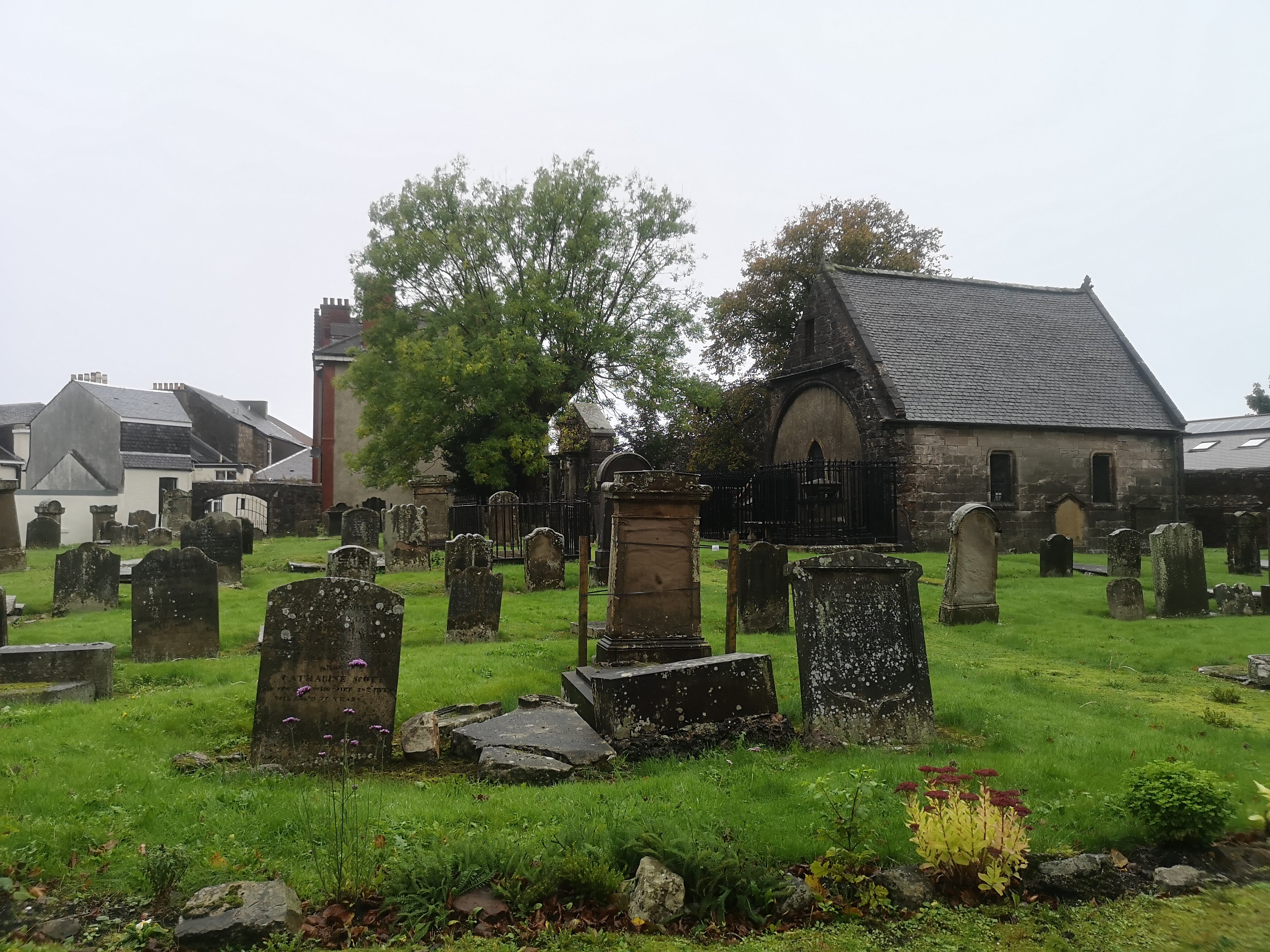
I wandered past the Skelmorlie Aisle where the Montgomerys from the castle are buried, but it was all locked up as Largs appeared to be battening down the hatches for winter.
 |
| Skelmorlie Aisle |
 |
| Finally got my ice cream |
For me today it was time to get the train back to Glasgow and dry off. I was glad to finally make it to my intended final destination, after an 18 month delay, and hope this is the start of a normality returning. Writing this now in October 2021, I can only hope that the next few months will tell us if Covid abates, but this is still the fear that it could rise again over the winter months. We shall see.
If you reach Largs on a drier day or with better visibility, you may want to head another mile south along the promenade to see "The Pencil" monument. Erected in 1921 to commemorate the Battle of Largs it mistakenly located the battle here, and mistakenly used a medieval defensive round tower design which wasn't deployed against Vikings.
 |
| The Pencil monument |
If views is what you are after (not available today) go through Douglas Park and follow the steps and path up Castle Hill. You will pass the chambered tomb above Haylie Brae that dates to 3000BC, keep going up the steps, up the path, and on a clear day the view over Largs makes the effort worth it.
 |
| Burial mound Largs |
 |
| Follow the steps |
 |
| View from Castle Hill, Largs |


Interesting details, thank you 😊
ReplyDelete