At the end of last year I spent a few weekends running
The Fife Pilgrim Way, a new long distance footpath from Culross to St Andrews. I enjoyed the challenge, particularly as it took me away from running my usual jogging routes in Glasgow again and again. So this year, to explore the rest of Central Scotland I plan to complete my run across Scotland, from the Ayrshire coast to the Fife coast at St Andrews.
This middle section takes me from the River Clyde in Glasgow to Culross on the banks of the River Forth.
 |
| Falkirk to Culross |
Glasgow to Culross - Part 3 - Falkirk to Culross
Falkirk to Grangemouth
Falkirk is a more historically important part of Scotland than you might imagine if, like me, you only ever come here on away days to watch lower league football. 2000 years ago the eastern end of the Antonine Wall passed through the spot where the town now sits, the northernmost extent of the Roman Empire in Britain. However, after a couple of decades the Romans decided that there was nothing here for them and they retreated back to Hadrian's Wall.
A millennium later The Battle of Falkirk in 1298 was a major defeat for the Scottish forces led by William Wallace, when Edward Longshanks came north again and this time hammered the Scots.
In the 1700s Falkirk was home to one of the largest cattle markets in Scotland, but 100 years later it was as an industrial town that it grew in importance. At the junction of the Forth and Clyde Canal and the Union Canal, its good transport links led to the development of many industries, particularly iron foundries, like the Carron Ironworks which used local iron ore and coke derived from local coal. By 1814 this was the largest ironworks in Europe, employing 2000 people. It had produced James Watt's first steam engine, and cannons deployed by Wellington at the Battle of Waterloo. This created great growth in the town, but by the 20th century, the decline in the local industries led to a decline in the town.
I
ran here from Glasgow along the canal, so decided to follow the canal to its end when I arrived back in town today. After passing the Falkirk Wheel which connects it to the Union Canal, the
Forth and Clyde Canal heads towards its eastern sea lock at Grangemouth and the River Carron.
 |
| Callendar House, Falkirk |
 |
| Callendar Lake, in Callendar Park, Falkirk |
Arriving back at Falkirk High train station I ran down through Callendar Park as a fine winter's morning was dawning.
Callendar House here dates back to the 14th century, but was re-modelled in the style of a French chateau in the 19th century. A ditch of the
Antonine Wall cuts through the grounds near to the house.
Having initially headed off on a wild goose chase up the verge of a B-Road that didn't have a pavement, I eventually got back onto safer ground near
Falkirk Stadium. To me this seems brand new, but
Falkirk Football Club have been playing here now since 2004, when
Brockville, their home since 1885, was demolished and the land sold. To be honest, if it hadn't been demolished, it looked like it was going to fall down by then, after decades of neglect. Falkirk where denied promotion to the SPL in 2003 due to their stadium not meeting the top league's (ever changing) criteria, which forced the move. Nine million pounds from Morrisons, who built a supermarket on the land, probably helped sweeten the move (not sure how reliable this figure is, but if
Wikipedia says it, it must be true).
 |
| Falkirk Stadium early in the morning |
The area between Falkirk Stadium and the River Carron was redeveloped as part of the Forth and Clyde Canal regeneration. When the canal was re-opened in 2001, a new lock into the River Carron had to be devised as the former route of the canal where it entered the river at Grangemouth docks had been obliterated by roads and housing. The new lock was less then ideal at either low or high tide on the River Carron and as part of a project to improve the area a new connection to the River Carron was devised and a park with cafes, walkways and play areas was created. The
Helix Park was the end result, its most recognisable feature being the much loved
Kelpies.
 |
| The Kelpies at Falkirk |
The 100 foot tall sculptures recall the heavy horses that used to pull barges along the canal, but kelpies are also shape-shifting spirits associated with water in Scottish folk tales. These malevolent creatures would lure you towards them, either in the form of a horse or a young woman. Once you were in their grip you would be pulled to your death below the water.
 |
| Lock gate between the Kelpies marina and the River Carron |
 |
| The Kelpies |
As you can see from the picture of the lock gate above at the River Carron, at low tide on the river the drop is too great. However at high tide, there is little space to allow any boats to pass under the M9 and other bridges on the River Carron. A short stretch of canal was cut parallel to the river to take boats further downstream to avoid this problem. Along this stretch The
Charlotte Dundas Heritage Trail tells the story of the Grangemouth boatyard, where the early steamboat
Charlotte Dundas was built.
 |
| Kelpies seen from the new stretch of canal after it passes under the M9 motorway |
Grangemouth to Kincardine
Grangemouth grew up around the docks that were here, but now the main employer is the Ineos refinery and petrochemical plant. The chimneys, cooling towers and gas flares here, usually shrouded in steam, are a distinctive feature of this part of the world, visible from miles around. I was talking once to a guide at Culross, the historic and scenic village across the River Forth from Grangemouth, about what he thought of the dystopian vision across the water. He made me look at it anew, as he delighted in its lights and steam, showing that the area could still provide skilled jobs for local people, and that we weren't stuck in the past here, becoming a heritage curio.
 |
| Grangemouth refinery |
He is right, but this type of industry is itself now becoming something of the past, like the coal mines that once were seen all across the central belt. They have all now completely vanished. In a world of climate change we need to move away from relying on fossil fuels, and create new technologies and industries. Government investment in order for us to get from where we are now, to where we need to be still seems to be pie in the sky despite the evidence of our own eyes that climate change is having an effect on our world already.
 |
| River Carron, west of Grangemouth |
As the canal heads down towards the Grangemouth refinery, I headed north across the River Carron and on towards the Kincardine Bridge. This area of land has tidal wetlands down by the river and can be home to flocks of birds, like the many geese that I scared into the air today as I ran through here. Two horses gave me a disinterested glance, briefly looking like a Kelpies tribute act.
/ |
| Kelpies or horses |
Skinflats has got to be one of the best/worst names for a village in Scotland. Anyone who has driven across the Kincardine Bridge will know the name from the road signs pointing it out before you cross the bridge. Purely to satisfy my curiosity I took a short detour through the village before following the old paths down in the direction of the River Forth. Formerly a mining village, the pits have all now gone. However about 300 people still live here, amongst farmland and wetlands, with views across to Grangemouth. By the waterfront much work has recently been undertaken on what is now an RSPB reserve to
recreate saline lagoons. This makes a perfect environment for certain terns, avocets and plovers and is a spot where numerous rare waterbirds can be found.
 |
| Skinflats |
 |
| Grangemouth seen behind an old farm building at Skinflats |
 |
| Path towards the River Forth |
Not wanting to get too bogged down in the mud I headed northwards towards the bridges again, zig-zagging along various paths. As Grangemouth's chimneys faded into the distance, the tower of
Longannet Power Station on the other side of the river came into view. Longannet was the last coal-fired power station in Scotland. When it opened in 1970 it was the largest coal-fired power station in Europe, and it operated until 2016. The site has now been ear-marked to become a
train manufacturing factory, which is expected to open in 2023.
 |
| Grangemouth |
 |
| Looking across farms and the River Forth towards Longannet |
 |
| Longannet and Grangemouth on either sides of the River Forth |
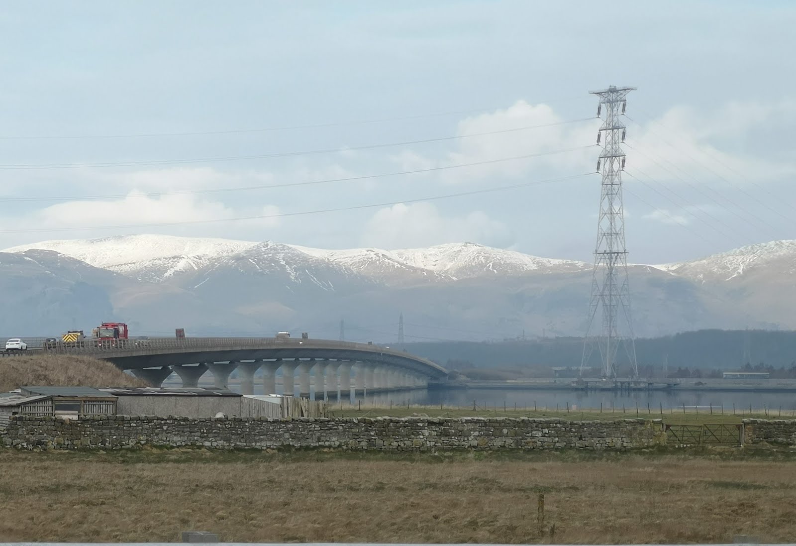
Two bridges now cross the River Forth at Kincardine. The original
Kincardine Bridge was opened in 1936, thirty years before the Forth Road Bridge at Queensferry. A central pivoting section could be swung round to allow ships to pass up river to the port at Alloa, but this has not functioned since 1988. Due to increased traffic and congestion, a new bridge across the river was built here, and opened in 2008.
The Clackmannanshire Bridge is in the curious position of the north approaches being in Clackmannanshire, the span of the bridge in Fife, and the southern approaches being in Falkirk council area.
 |
| Clackmanannshire Bridge with snow-topped Ochil Hills beyond, March 2020 |
 |
| Central pontoon on the Kincardine Bridge, looking downriver |
 |
| Kincardine Bridge over the River Forth |
Kincardine to Culross
After running across the bridge I had a quick stoat about Kincardine, basically because it is a town that I often drive past but have never stopped in. It has a surprisingly old feel to it, despite being sliced up by a century of major roads being cut through the town. The town itself dates back 500 years and was at one time a fairly substantial port, with ferries frequently used by drovers taking their cattle to market in Falkirk. At low tide the old jetty and the skeletons of some old wooden boats were visible in the mud.
 |
| Kincardine Bridge from the slipway in Kincardine |
 |
| The rotting hulls of old wooden boats in the mud at Kincartdine |
As I wanted to visit the old
Tulliallan Kirkyard I popped into
Marco's Kitchen, a cafe at the bottom of Kirk Street, where the key and guidebook to the graveyard are kept. Tulliallan Old Parish Church was built in 1675 and replaced in 1832 by a new church on another site, leaving the old kirkyard and church building like a time capsule. The
local history group have made a great job of restoring the gravestones and maintaining the churchyard and their website is a treasure trove of information on the beautifully carved gravestones to be found here. Many of them have emblems of the occupation of the deceased carved on the stone, everything from painters and coal miners to farriers, sailors, tailors and foresters.
 |
| Marco's Kitchen, Kincardine |
 |
| Old Tulliallan kirkyard |
 |
| From 1767 a gravestone with an anchor, a weaver's shuttle, carding comb and stretchers, an hourglass, crossed bones and skull |
 |
| A woodcutter chopping down a tree, 1787, with the motto "As the tree falls so must it ly." |
 |
| Shield with pendants, lances and crossed flags. "Erected in memory of William Greig. Died 16th November 1805 aged 32." (A soldier/sailor it is believed that he may have died from injuries sustained at the Battle of Trafalgar, 21st Oct 1805) |
Having remembered to drop off the key again, I was able to join the
Fife Coastal Path and run along the last part of today's route to Culross while avoiding the roads. The path goes past Longannet Power Station just outside Kincardine before winding its way to Culross.
 |
| Fife Coastal Path at Kincardine |
 |
| Longannet Power Station |
Coming into Culross means that I have now joined up to my route from a couple of months ago, when I
started at Culross, to run towards St Andrews. As it was such a lovely day I wandered out to the end of the pier at Culross, facing towards Bo'ness on the other side of the Forth. "Do not throw stone" the message reads to prevent people chucking bits of the old pier into the river. The end of the pier at Culross looks across the River Forth to Bo'ness where my great-great-great-great-great grandfather was born in 1751. Three generations of nautical trades later my great-great granny, Agnes Donaldson, headed west and married a stonemason in Rothesay.
 |
| Culross pier |
Before lunch in one of the town's cafes I wandered back up the hill to
Culross Abbey. In the abbey the Bruce family burial vault contains the ostentatious monument to Sir George Bruce, who died in 1625, the former resident of Culross Palace at the bottom of the hill. This includes marble carvings of his eight children piously praying by his tomb. On a wall in the tomb is a curious plaque to another Bruce. It records that the heart of Lord Edward, Lord Bruce of Kinloss, has been deposited here. He died fighting "
a bloody duel" in 1613 with the Earl of Dorset, near Bergen in Holland, "
in which country the combatants had repaired, the one from England, the other from Paris, for the determined purpose of deciding their quarrel with the sword."
 |
| Memorial to Edward, Lord Bruce of Kinloss |
 |
| Monument to Sir George Bruce, in Culross |
So I have now enjoyed running from Glasgow to Culross, and from Culross to St Andrews. Now I think it is time to turn west, and head from
Glasgow to the Ayrshire coast.


No comments:
Post a Comment
Due to the volume of spam which some posts attract, all comments are moderated, which may cause a delay before they appear. Thank you for your patience.