I recently read a book about Scottish war artists. Although there wasn't a picture of it, the book mentioned a painting called "Bomb Crater, Knightswood" by Ian Fleming, painted after the Clydebank blitz. I spent my teenage years in Knightswood in Glasgow and although I knew that huge parts of Clydebank had been flattened during the war, I really had no idea which areas of Glasgow had been bombed. So I decided to have a look about for any remaining signs of war damage.
Clydebank Blitz
Over two nights on the
13th and 14th of March 1941, Clydebank suffered intense attack from the Luftwaffe as they tried to destroy shipbuilding and industrial targets in the town. Afterwards only seven of the 12,000 houses in the town were left undamaged, with 4,000 completely destroyed and a similar number severely damaged. Remarkably the industrial sites survived relatively unscathed and were soon able to return to full production. However the number of people made homeless who had to move away and the civilian casualties caused long-lasting hardship to the residents of the town. On those two nights numerous targets in nearby Glasgow were also bombed, with a greater loss of life but spread across a wider area. According to official figures (which some feel may be an underestimate) the two nights of bombing led to the deaths of 528 people in Clydebank and a further 650 in Glasgow.
The main targets in Clydebank were the
Singer Sewing Machine factory, which had switched to munitions production during the war,
John Brown's Shipyard and
Beardmore's engine works. My great-uncle Andy worked in
John Brown's Shipyard in Clydebank. Travelling daily from his home in
the Gorbals, he was 14 years old when he started working in the yards as a "bilge boy" on the construction of HMS Hood. This work involved holding a candle, and going down with a bucket to the lowest parts of the ship to collect dropped rivets and tools. Work in the shipyards paid much better than many other industries and he was paid 30 shillings for this. At the time of the Russian revolution he remembered tossing his bunnet into the air when he and other workers celebrated the news from Moscow (he remembered it because he lost his bunnet that day). On the day of the armistice in 1918 everyone was sent home from the shipyard at 11am, except the gatekeepers. Oblivious to all of this, as he was working deep in the lowest parts of the ships, he emerged later to find the shipyard like a ghost town, and had to walk home to the Gorbals, as there were no buses then running. He later became an engineer and for two years during the depression of the 1930s was entirely unable to find any work. As war approached, shipbuilding picked up again and he was back to work in John Brown's. He was still working when I joined a march through Glasgow, in my pram, to support him and his co-workers in
the UCS work-in in the early 1970s, and he retired when the work-in ended in victory.
He was working nightshift in John Brown's Shipyard on the night of the blitz, spending most of the time in underground shelters. He found it difficult to comprehend the total devastation he witnessed walking home towards Glasgow through the rubble that first morning after the bombing. I was only a child when he told me these stories, but the memories of the Clydebank blitz never left him.
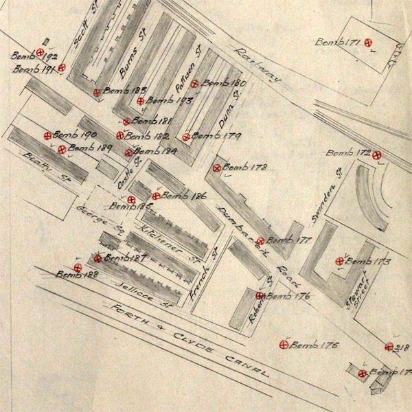
 |
| Records of bombs landing on Jellicoe Street north of the Forth and Clyde Canal at Dalmuir opposite the engine works |
The highest density of bombing on those nights was over Clydebank. The map above shows the bombs that landed around Jellicoe Street in Clydebank. One family in this street suffered particularly when 14 members of the Rocks family, at number 78, died in the bombing.
Just before 9pm on the 13th of March the first German aircraft were spotted coming up the Clyde. The first wave usually dropped incendiary bombs to start fires and guide subsequent planes carrying bombs with move explosive power. Early in the first night of bombing in Clydebank the incendiary bombs ignited the timber store at Singers factory and Yoker distillery began burning furiously. By the next morning it was as if the whole town was on fire. My wife's grandad was a coalminer in Fife and he remembers looking west from Lochgelly that evening and knowing something awful was happening, as he could see the horizon glowing.
 |
| Photograph taken from Great Western Road/ The Boulevard on the night of 13th March 1941 with Clydebank ablaze. The Singer tower can be seen in the centre of the picture |
Glasgow during the Clydebank Blitz - 13th March 1941
Glasgow had always been identified as vulnerable to German attack, and with its high concentration of heavy industry was expected to be a target. Anderson shelters could be built in gardens in leafy Knightswood and Mosspark (and many were still standing as garden sheds when I was a kid), but the densely populated, tightly packed tenements in the city meant that bombs landing here could cause many casualties. Communal shelters were built in some streets and back courts. Other tenements had to make do with "strutted close-mouths", wooden beams put up to try to make a safe area from potential collapse of the building above. This was in the days before closes had doors, leaving residents huddling together through the night, exposed to the elements in event of an air raid (a concern that was
raised in Parliament at the time).
 |
| Ian Fleming. Shelters in a tenement lane, Glasgow |
As well as the shipyards of Clydebank, other targets that the Germans had identified were the oil depot at Old Kilpatrick, the many shipyards in Glasgow, industries in Parkhead and Springburn, Port Dundas power station and, as you can see in the German reconnaissance photograph below,
Dawsholm gas works, and rubber and chemical factories along the banks of the
Forth and Clyde Canal. It was realised that a bomb damaging the canal could cause extensive flooding and several emergency "Stop Locks" were built. These could be closed to reduce this risk in the event of damage to the canal. The remnants of one of these can still be seen at the Stockingfield Junction, above Lochburn Road.
 |
| Emergency Stop Lock on the Forth and Clyde Canal |
 |
| German Luftwaffe reconnaissance photograph over Wyndford and Maryhill, with potential bombing targets highlighted |
Reports of incendiary devices landing on Clydebank started to arrive around 9pm on the 13th of March 1941. Bombs were soon reported falling on Drumchapel and High Knightswood just north of Great Western Road. This has often led to the suggestion that many German pilots were mistaking the long, wide Great Western Road, glinting in the moonlight, for the River Clyde or the Forth and Clyde Canal, and were dropping their bombs on these residential areas in error, missing the industrial targets to the south.
Shortly after the first bombs fell on Clydebank a "parachute landmine" exploded in the playground at Bankhead School in Knightswood. The school was used as an ARP station, home to the Auxilliary Fire Service and a first aid post. Parachute mines were designed to explode upon landing, spreading the force of their blast wider than bombs that buried themselves in the ground and they caused much of the damage across Glasgow that night. Thirty nine people were killed by this explosion at Bankhead School, including two "boy messengers".
Bankhead Primary School was re-opened after the war. When her family were moved to Drumchapel from the
Gorbals in the late 1950s, my mum spent her primary 6 and primary 7 years at Bankhead Primary.
 |
| Bankhead School before the war |
 |
| Wartime painting by Ian Fleming. "Bomb Crater, Knightswood" with the typical housing of this area visible in the background |
 |
| Memorial in Bankhead Primary School to those who died there that night |
The German airmen recorded anti-aircraft fire started at 9.35pm. Anti-aircraft guns were located up and down the Clyde coast, in Glasgow at Kings Park and Carmunnock on the southside, at Station Road in Bearsden and out near Khyber Pass in what is now Mugdock Park. You can still see the structures where these guns stood in Mugdock Park, and look down towards the Clyde.
My granny spent her army years during the war working in an anti-aircraft gun unit at Portishead near Bristol and told me what her days there were like. As well as concentrating on targeting the enemy aircraft, the gunners were themselves a target. When she wasn't on duty, my granny can recall sleeping in the nearby Nissen hut with dirt and shrapnel, thrown up by German bombs, peppering the roof through the night.
 |
| Anti-aircraft gun emplacement above Glasgow in Mugdock Park |
 |
| Anti-aircraft gun operation room in Mugdock Par,k which received information and passed targeting details to the gunners. Officers and women from the ATS (like my granny) worked in these bunkers, as women were not allowed to actually fire the guns |
 |
| One of four gun emplacement, surrounded by ammunition stores, above the River Clyde in Mugdock Park |
By 11pm extra fire engines were being called in to Clydebank to deal with the fires now blazing there from Kirkintilloch, Motherwell, Helensburgh and Coatbridge. Before midnight in Glasgow, bombs had also landed in Govan and at the junction of Radnor Street and Argyle Street. The St Enoch Free Church building that stood at the gushet where Old Dumbarton Road and Argyle Street meet later had to be pulled down due to the bomb damage. For many years this became the site of a BP garage stood there, before recently giving way to a block of student flats.
 |
| Former site of the St Enoch's United Free Church, at the corner of Old Dumbarton Road and Argyle Street in Glasgow |
Two mines had landed in Kelvingrove Park. One of them landed on Kelvin Way near the bridge over the River Kelvin, damaging the statues there (a plaque records the subsequent repairs) and also blew out windows at Glasgow University and Kelvingrove Art Gallery. The statues at the northern end of the bridge were damaged, allegorical sculptures which represent Peace and War, Philosophy and Inspiration. The exploding landmine blew these sculptures into the River Kelvin where they lay until 1949. It wasn't until a hot spell in 1995 made the river levels in the Kelvin fall very low that a passerby spotted a missing arm from one of the sculptures, that had lay in the water for over 50 years.
This newspaper report confirms that satisfied with the earlier 1951 repair, the city council did not plan to re-attach the original arm.
 |
| Statues on Kelvin Way which were damaged by a German bomb. These figures represent "Peace" and "War" |
 |
| Statues on Kelvin Way which were damaged by a German bomb. These figures represent "Philosophy" and "Inspiration". Many windows in Glasgow University, visible in the distance here, were smashed by the explosion |
 |
| Plaque marking the repair to these statues in 1951 |
At 11.30pm a landmine and five bombs landed in Partick on Sandy Road, Hayburn Street, Dumbarton Road and on Peel Street, where the most extensive damage occurred. On Peel Street the tenements on the western side of the street opposite the
West of Scotland Cricket Club were destroyed. When the buildings collapsed here 50 people lost their lives and survivors were being pulled from the rubble for days. In several other spots nearby modern flats standing amongst the old tenements show where bomb damaged buildings had to be pulled down.
 |
| Few old tenements still stand down the west side of Peel Street, most were destroyed by bombs in 1941 |
Just before midnight a parachute mine lands on offices at Yarrow's shipyard in Yoker, collapsing an underground shelter below. 200 men are trapped inside and 67 of them die. Many tenements in the neighbouring streets of Scotstoun and Yoker were also being hit around this time. A mine landed on shelters between Earl Street and Dumbarton Roan, killing 66 people. In Hyndland a bomb landed at Queensborough Gardens and mines fell on Dudley Drive, Airlie Street and Turnberry Road. On Dudley Drive numbers 8, 10 and 12 collapsed and across the road numbers 7 and 9 later had to be demolished. 36 people died here and 21 were injured. You can see the difference where the gaps on Dudley Drive were filled after the war with red sandstone tenements.
 |
| 8-12 Dudley Drive, 36 people died when a landmine landed on the tenement here, rebuilt in the 1950s |
 |
| 7 and 9 Dudley Drive, demolished due to bomb damage and later re-built |
On the southside of Glasgow bombs and mines landed in Chapel Lane in the Gorbals, the Co-op warehouse on Morrison Street and nearby on McLure and McIntosh's knitwear factory on Florence Street (known after its owners, as the "Twomax").
On Govan Road, where a petrol station now sits in a gap site near to the Clyde Tunnel roundabout,
three tenements were destroyed by a parachute bomb aimed at
Stephens Linthouse shipyard across the road. 69 people died in this attack.
 |
| Petrol station on Govan Road at site of bombing which destroyed three tenements |
 |
| Bomb disposal officers successfully defuse an unexploded land mine which fell on Glasgow |
The destructive power that these parachute mines had was made clear when one landed between a tram and the tenements on Nelson Street, at the junction with Centre Street in Tradeston. 110 people died from this blast (pictured below) including three French sailors on the other side of the Clyde, on the Broomielaw. Eleven of those that died were on the tram from which twenty people were rescued, remarkable given the damage that occurred here which you can see in the picture below. Many more people were injured in the collapsed buildings surrounding this, or trapped in underground shelters. This was the worst loss of life in any single incident during a bombing raid on Scotland during the war.
 |
| A parachute mine lands between a tram and the adjacent tenements on Nelson Street, Glasgow |
 |
| Junction of Centre Street and Nelson Street today. The destruction started by the Luftwaffe in 1941 was completed by Glasgow City town planners in the 1960s with this formerly bustling area being a jumble of run down warehouses to this day |
A parachute mine lands on Queen Margaret Road at the junction with Queen Margaret Drive and Wilton Street. The BBC building across the River Kelvin was thought to be the intended target. If you look at the red sandstone tenements here, just west of
Alexander 'Greek' Thomson's "Sixty Steps", you can see that the mine caused the complete destruction of the last block in the road, which was rebuilt in the 1950s. Damage from the mine can be seen still on the nearby bridge over the Kelvin. A second mine which fell on 84 Kelvin Drive, at Clouston Street (at that time The Aberholme Hotel), crashed through the roof with its parachute still attached, but did not explode.
 |
| Tenements on Queen Margaret Road, the original tenement in the foreground and the later replacement in the distance of the tenement destroyed by German bombing |
 |
| Queen Margaret Bridge shows signs of damage from the landmine which destroyed the tenement building across the road |
Shortly after the bombing stopped in Clydebank, the last bomb of the night fell on Glenburn Street in Maryhill at 5.35am. Those buildings in Clydebank which had not collapsed with the intense bombing there during the night, all seemed to be on fire as day dawned.
The Polish destroyer
ORP Piorun (meaning Thunderbolt) was in John Brown's Shipyard for repairs on the night of the German bombing of the town. During the raid the commander of the ship, Eugeniusz Plawski, got his men to direct fire from the ships guns towards the German aircraft overhead. It is believed that this may have steered some planes away from dropping their bombs over the yards. For their bravery there is a memorial to the Polish crew of the ship in Clydebank's Solidarity Plaza. Eight weeks after that night during the Clydebank Blitz the
ORP Piorun was among the ships hunting the
Bismarck, and the first to spot her. Until support arrived, the captain had his ship charge at the
Bismarck alone sending radio messages to make sure that she knew it was a Polish ship was attacking them.
 |
| Solidarity Plaza in Clydebank, dedicated to the sailors of O.R.P. Piorun, "defenders of Clydebank". |

The Second Night - 14th March 1941
With rescues still ongoing among the rubble in Clydebank and Glasgow, when darkness fell the following night the air raid sirens sounded again. The first bomb of the night fell just before 9pm, again north of Great Western Road in Drumchapel destroying the post office. Soon afterwards bombs were falling again on Clydebank and in Drumchapel, near the train station.
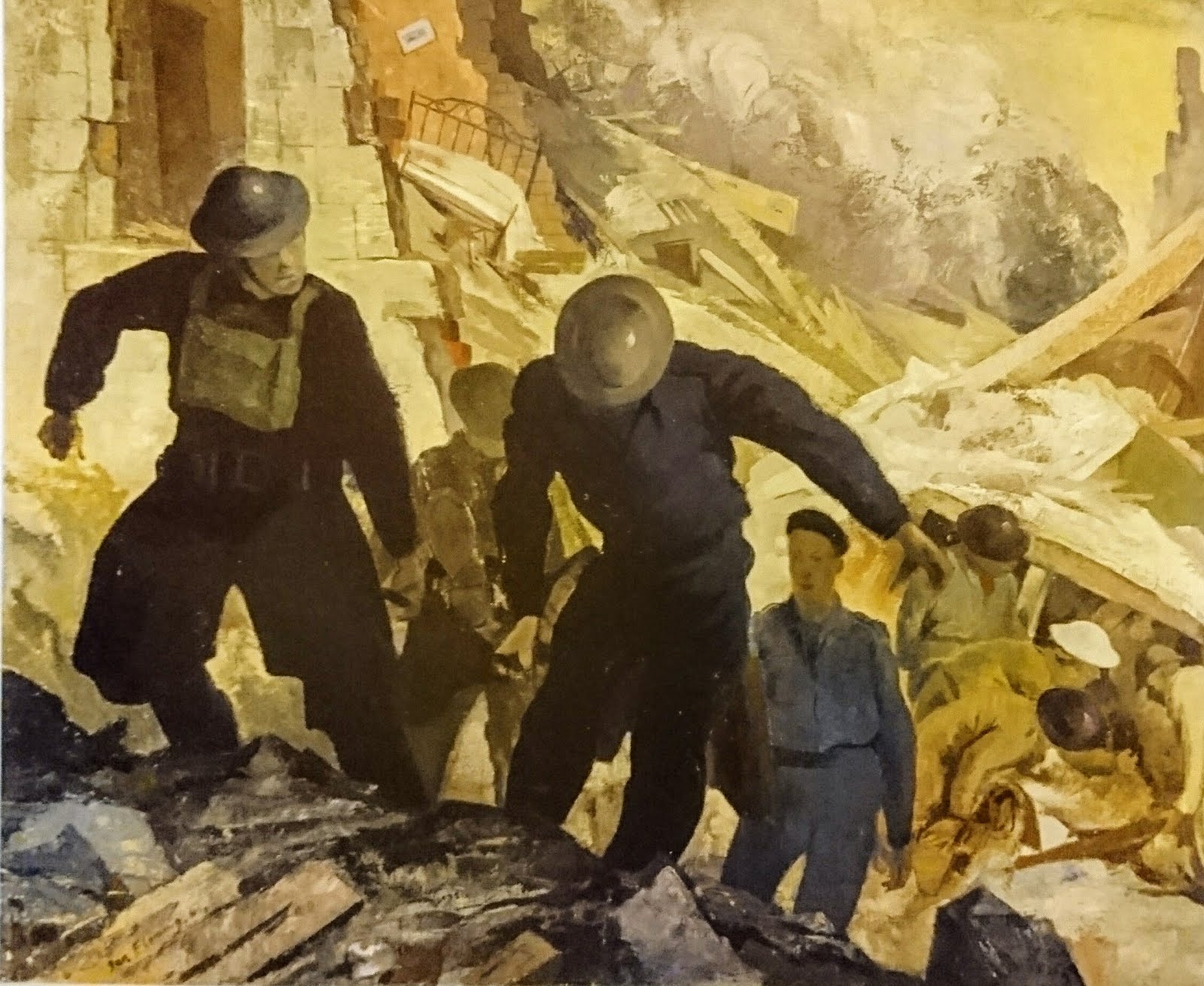
 |
| Ian Fleming . Blitz Maryhill, Kilmun Street |
Just before midnight two mines fell on
Maryhill. The first exploded in a field by Duncruin Street and the second on the tenements of Kilmun Street. Kilmun Street runs off Maryhill Road, just behind St Mary's Primary School. The collapse of the buildings here led to the deaths of 83 people. Rescuers coming to the area reported that Maryhill Road was increasingly covered in broken glass the nearer they got to the site. The local school was the designated first aid post in the area, but was also damaged by the blast, with many windows broken. Whilst rescues carried on through the night in the rubble, as seen in Ian Fleming's painting below, many survivors were gathered together down at the tram depot on Celtic Street.
 |
| Ian Fleming. Rescue Party, Kilmun Street 1942 |
 |
| Kilmun Street in Maryhill lies empty today |
 |
| Street sign at Cumlodden Drive/ Kilmun Street junction |
Elsewhere on the Clydeside that night ships were damaged by bombs falling on Dalmuir Basin, Princes Dock in Glasgow and at Denny's Shipyard in Dumbarton. A mine also exploded in the Clyde at the mouth of the River Cart, beaching a tug. The Old Kilpatrick oil tanks, which were still ablaze from the previous night's attack, were bombed again. Two mines landed on the Clydebridge Iron Works in Cambuslang, but didn't explode. Other bombs caused minor damage at Sheildhall Power Station and at Sheildhall Wharf and Stephen's Shipyard.
Firdon Crescent next to Drumchapel train station was hit, bombs landed in Knghtswood at the junction between Waldemar Road and Chaplet Avenue, on Alderman Road and on Lincoln Avenue at the junction with Archerhill Road (I lived in the high flats here for 10 years, oblivious to this fact). Six people were killed in Knightswood that night and six houses destroyed. Great Western Road was closed at Drumry when a bomb left a huge crater in the road here.
In Bridgeton a parachute mine destroyed a tenement on Allan Street. This started a fire at the nearby methylated spirit works and 600 people here lost their homes. Other planes appeared to be dumping their bombs before returning to Germany or had been completely disorientated in their targetting, as this night bombs also fell in Drymen, Blanefield, Fintry, Neilston and Barrhead. 27 bombs fell on Erskine Hospital, home to disabled veterans of the first World War, presumably intended for the nearby munitions works in Bishopton. Four bombs fell on the Isle of Bute in the hills behind Rothesay, and one "fell three miles west of Sannox Bay on the Isle of Arran".
At 6.15am the all clear was sounded in Clydebank, a town which over two days had been flattened.
 |
| Edward Ardizzone. Bombed Out (Glasgow) 1941 |
The civilian population of Glasgow and Clydebank were the ones that suffered during the German bombing attacks on the Clydeside. The shipyards and many other industries in the city suffered relatively little damage from bombing. Terror and demoralisation of civilian populations by bombing has been argued as part of the justification of such attacks as much as any military advantage gained, or
shock and awe, to use the modern vernacular.
 |
| Walls marked by shrapnel at the former bath house in Clydebank |
Other bombing raids
The first attack on Glasgow was in July 1940, and the last air-raid was in March 1943. The worst bombing was the nights which I have described above, but further major bombing raids occurred in Glasgow and Clydebank in April and May 1941. The raids in May again led to extensive bombing in Glasgow, but the main target was Greenock. Despite the shipyards and Beardmore diesel works there being the target, again it was the civilian population that bore the brunt of the attack. On the night of May 6th 1941 in
Greenock 10,000 homes were damaged, 280 people killed and 1200 injured.
 |
| Rescuers among the rubble of a Glasgow tenement destroyed by German bombing |
Another incidents of note in Glasgow during the war was the sinking of
HMS Sussex, bombed whilst in
Yorkhill Quay for repairs. In September 1940, a bomb struck her fuel tanks and the ship caught fire and was sunk, later to be salvaged and repaired. Also in 1940
Merkland Street subway station (now called Partick Station) was hit by a bomb and closed for several months. Apparently if you know where to look in the tunnel between Partick and Govan stations you can see the repairs that had to be carried out.
Deanston Drive in Shawlands was struck by bombs in an attack later in the war, putting pay to the mischievous rumour in Glasgow at the time that Hitler's mother must have come from Shawlands, as it always seemed to be missed during bombing raids. There is apparently shrapnel damage visible in some of the tenement walls near here.
 |
| Queens Park UP Church, Glasgow |
Queens Park UP Church on
Langside Avenue, one of the most impressive buildings designed by
Alexander 'Greek' Thomson, was destroyed by an incendiary bomb in March 1943, and the ruins flattened.
In the Barrowlands area, a bomb destroyed the tenement at the junction of
Kent Street and
London Road where Rossi's Cafe once stood.
In the city centre bombs landed in September 1940, destroying buildings just north of the
City Chambers on
Martha Street and
North Frederick Street. Also the two modern buildings at the end of
Ingram Street at the junction with
Queen Street were replacements for bomb damaged buildings, the one at the corner south of Ingram Street destroyed by a bomb, and the building across the road damaged by the same explosion.
 |
| Queen Street at Ingram Street |
There are maps in the Mitchell Library which record many of the bombs which landed on Glasgow, but nobody has pulled this information all together for the city in an online map, the way people have done for
Clydebank or
London. The maps record bombs which landed between 1940 and 1943 in
Dalmarnock, Shettleston, Bridgeton, Calton, Garngad, Hutcesontown, Tradeston and
Plantation. Destroyed houses are noted on
Boyd Street, Govanhill,
Crow Road, Anniesland and either side of Victoria Park in
Scotstoun on Eastcote Avenue and Lime Street.
 |
| Old houses on the left, new on the right, replacing bomb damaged houses on Crow Road |
Further west on the map the areas coloured in as war damage become more extensive. From isolated detonations in Maryhill and Kelvindale, to more widespread damage in Knightswood, Drumchapel, Drumry, Garscadden and Yoker. In areas with sparser housing the casualties were fewer, but wherever a parachute mine landed on an area of more densely populated tenements, a single blast caused significant deaths.
 |
| Map of Glasgow war damage, Mitchell Library |
As contemporary newspaper reports were so heavily censored they do not contain a useful record of the hardships faced by cities targeted by bombers. Looking back at newspapers of the time they talk vaguely about "a Clydeside town" being bombed, or talking about heroic rescues from the rubble, avoiding any details which may have proved useful to the enemy. From the start it was clear that the attacks on 13th and 14th of March were being called a "blitz", as can be seen in this article below from the
Daily Record, on March 27th 1941. The article here about the "Clyde Air Raid Distress Fund" mentions that a German bomb fragment was reported to have had the word "Dollan" on it (aimed at the prominent Lord Provost of the city,
Patrick Dollan.) In response an RAF Sergeant advised the Record that he had carved "
Let Glasgow Flourish" on a bomb he had since dropped on a German town. Tit-for-tat that continued through the war, and does rather omit the "
by the preaching of the word" second half of St Mungo's quote that makes up the city motto.
 |
| Daily Record 27 March 1941 alludes to the bombing of Glasgow and Clydebank |
As the number of people still living who were alive in Glasgow during World War Two becomes smaller each year, these events fade from living memory. It is therefore important to hear their stories in order to learn from the events of the past.
Much of the info from this blog came from the following sources...


The Heavy AA Guns at Station Road Bearsden -the actual address was 500 Garscadden Road with a Drumchapel address as this area was within the Glasgow city boundary by 1941. Joined 1938.The HAA guns at Garscadden Mains were the second radar controlled guns in Scotland. Just fully operational first night of Clydebank blitz. They ran out of ammo half way through the second wave.Told to me many years ago by
ReplyDeleteex gunner on the site. It was also the 2nd or 3rd mixed male/female gunsite in Britain. I have a picture from about October 1941 with women all in mens Royal Artillery uniforms and insignia on the gunsite.
The battery was codenamed N4 and may have been armed with 4.5 inch and/or 3.7 inch guns
ReplyDeleteI was only a toddler at the time all this was going on, but I clearly remember hearing the sirens, the bursts of AA fire and the terrifying drone of the bombers. Living near Parkhead Cross and Beardmore's steel foundry, we were targeted several times by the Luftwaffe. One parachute mine hit the river bank near the Westthorne Park. The blast blew out windows in our street but no- one was injured or killed. Terrible times.
ReplyDeleteThat is very fascinating, You're an overly professional blogger.
ReplyDeleteI have joined your feed and sit up for in quest of more of your fantastic post.
Also, I have shared your site in my social networks
Would Crawford Street have been hit during these raids too? I didnt see it mentioned specifically but I noticed that the area where my mothers family lived until they immigrated to Canada seems to no longer have the tenements that she spoke about to us as children. Coming to Glasgow this year and hope to see some of the areas she lived and grew up.
ReplyDeleteNo, the tenements there were demolished in 1970s re-developments. Here is a link to the story of the mural that used to be on the gable-end of a tenement block in Crawford Street. Sadly in a lot of areas of the city what the Luftwaffe started in the 1940s, Glasgow Corporation finished over the following years.
Deletehttps://www.facebook.com/lostglasgowofficial/photos/a.265323076912889.52615.251032471675283/817219235056601/?type=3
I grew up in Partick in Vine St, many family members lived in Crawford Street and as long as I remember(going back to the 60"s)there was a gap in the buildings on the west side.
DeleteThere were a few closes north of Beith St and, I have a photo of a cousin taken in the '60's showing tis gap. I suspect it might have been bombed or was demolished for other reasons.
There must be a record of it somewhere
My mum and dad survived the bombing in lighthouse Stevens shipyard. Can remember walking past the site as a wee girl .
ReplyDeleteA bomb exploded in Springfield Rd destroying a soap work factory, years later that land became Riversides schools football pitch.
ReplyDeleteI remember my mum talking about being on Springfield road going to Wardrobe st when the sirens went off and the Soap factory was hit …. She lost a shoe running ….
DeleteFascinating reading. I ended up here as I am trying to find out more about a bomb which landed in Cathedral Street when my Nana lived there. She claims that they opened their curtains one morning to find a German oil bomb had landed outside (possibly unexploded?) after that she was evacuated to Lanark. Any further info would be very welcome. I have also searched an excellent thread on the Hidden Glasgow site but didn’t turn anything up.
ReplyDeleteThe Kennedy Street mine.
ReplyDelete========================
In many articles about mines in WW2 there is a photograph of a
defused, unexploded parachute mine. It is a 1000kg mine and it
has 6 policemen and two army personnel standing in a row behind
the mine. The photo was taken in Glasgow on 18 March 1941. There is a partially obscured nameplate behind the men
standing. Otherwise no other information about the location
appears to be available.
Using the 1914 Post-Office annual street directory, I established that the name is:
Grant, Cameron & Curle,
St Rollox spring van and lorry factory,
83 to 99 Kennedy Street,
off Paliamentary Road.
I used a combination of photos from the 1933 and 1948 National
Collection of Aerial Photographs and 1935 and 1951 Ordnance Survey maps to pin down exactly where the photo was taken. It is at the location of the old Britannia Pottery Works across Kennedy Road from the Grant, Cameron & Curle works. The pottery was founded in 1856 by R. Cochran, and ceased trading in 1935. By the time of the mine in 1941, much of the Pottery had been removed leaving an expanse of waste ground with a few low level buildings, two of which can be seen in the WW2 photo. It appears that by 1948 the ground was being used as an
overflow from the van works opposite, although the Grant, Cameron & Curle name is no longer showing on the building's front.
The tenements in the background are in Hartfield Street.
The low level builings are arranged roughly in three rows from west to east with each containing four buildings north to south. The mine photograph is just to the left of the second (middle) row, southernmost low level building just inside the Kennedy Street wall (see photo AFL 2120 SPWD 16062, 1948).
Hi, my father was one of the policemen in the photo, IM keen to identify the exact spot and any other related photos or information. Can you assist?
DeleteDavid Christie
Hi David,
DeleteSorry it has taken so long to get back to you. I've been focusing on the Clydebank Blitz recently.
I'm not sure how to attach photos nor what the copyright would be.
If you send me your email address I can send the photos to you.
The exact spot where the mine landed as far as I can tell is
between the ends of the two middle buildings closest to the wall
on Kennedy Street i.e. if you walk up Kennedy Street and enter
the main gate to what was then waste ground, the mine was lying
just to your left between the ends of the two buildings nearest
the gate.
From the NLS georeferenced map using the OS 1:1,250/1:2,500,
1944-1970 map I get the mine position to be 55.86744(N) and
-4.23808(W). This translates to 55deg 52' 2.8" N and 4deg 14'
17.1" W. The modern map shows this is in the middle of a car park
between Tesla Glasgow and Powerleague Glasgow.
Hope this helps.
Best regards
William Meikle
My mother talked about her cousins being killed in the Clydebank blitz by a "flying mine" but she would not go into details. Where can I find names of victims?
ReplyDeleteThe lists of those who died in the Clydebank bombings are sometimes accused of being incomplete. The official list as documented in Westminster Abbey can be found here. https://www.tommckendrick.com/code/casualties1.html
Deletein 1941 i was nine years old and lived in 16 deanston drive shawlands.our house was damaged and we were taken to langside school where we lived for a week in the gymnasium with other families James Grey street suffered the most damage and several folk were killed,My school mate Abagil Shaw who lived opposite was killed Other people were killed but i cannot remember their names .we lived in the school until we had a -house inAfton street
ReplyDeleteNot much about the Kent st bombing where the tenement on the corner was destroyed I believe there were fatalities but not much about it.. Also Edmond st Dennistoun cant find anything about that either.
ReplyDeleteApparently it was a stick of bombs that hit Bain St at Gallowgate end, Kent St at St Alphonsus Church an bottom of Charlotte St. I dont know where the Dennistoun St is located but chances are it was part of same stick of bombs from east to south west.
DeleteI remember my mum telling me that her mother, her sister and herself sought refuge in a bomb shelter in Glasgow Green during the night of the bombing of the tenements/shops at corner of Kent Street and London Road. At the time, all three lived two blocks away at the corner of Well Street and London Road. She told me that someone came into the shelter and told everyone (incorrectly as it happened) that the Germans had bombed the houses at the corner of Well Street and London Road and that there was nothing left! My mum relates how they all burst into tears and did not want to visit their house the next day. Eventually they plucked up sufficient courage to view the scene, only to find their house still standing, undamaged! Sad for the residents of the bombed out tenements (at the corner of Kent Street and London Road) though.
DeleteDue to the damage, (Peter ?) Rossi's cafe, extensively damaged in the raid, relocated futher along to 320 London Road.
Apparently a bomb also "demolished" a whole block of tenements on the east side of Risk Street, between Stevenson and Bankier Streets, Calton.
DeleteMy mother worked making Bofor guns in Glasgow. She was actually in Leadhills at the time of the Clydebank Blitz, She told me about the bombing of Clydebank and when she was in Leadhills that the night sky was cromson red with the bombing there. I grew up in Drumchapel and used to go to the Bombsite by the woods and the Burn. Was that an anti-aircraft site.
ReplyDeleteMy grandparents lived near Centre Street and when the bombing started my grandmother and my mum who was only eight years old hurried out of the tenement. Their neighbour was close behind. The woman then shouted "Mary I've been hit!" My Nana went back to help the neighbour up, but at this point the neighbour started to laugh. She hadn't been hit. She fell because in her hurry to get dressed she put her two legs through the one leg of her nickers!
ReplyDeleteI'm part of a local history group who'd love to hear more from you about the impact of the bombings on the West End
ReplyDeleteu3Agwehistorygroup@gmail.com
Has anyone put together the info on bombing in Glasgow? I was 4 years of age when Clydebank was bombed. I was in an above ground shelter on Pollock st near Scotland street school. I remember we could see the fire at Clydebank, but there was a fire up Shields road as well that Ive never identified. I'm writing about my experiences just fro the family history. I know Mitchell Library has the bombing maps but they are closed right now and, besides I live in the USA.
ReplyDeleteI couldn't find anything really on bombing in Glasgow online, which is why I tried to gather the information above on this subject. Yes, there is a bomb damage map in the Mitchell Library, which I consulted to write this above. It is not available in any digital form so until the Mitchell Library re-opens, it is out of reach.
DeleteHi,
ReplyDeleteI work in a charity shop, we have a framed pencil sketch of damage at Glenburn Street, 14th March 1941. Any idea who would be interested in having this?
Many many thanks for your time and effort. I enjoyed the read. I´m researching a novel where a brother and sister are parked on a hill over looking Clydebank and watch the raid (13th). I’m hoping to visit Clydebank soon and find a suitable hill but any suggestions would be appreciated.
ReplyDeleteDespite being fiction I will be as accurate as I can be and of course treat the subject with sensitivity. It must of been as close to living in hell as you can get. Again many thanks for recording history.
To look over Clydebank from a hillside you would need to be in the Kilpatrick Hills just to the north, or in Mugdock Park. As the shipyards were an obvious military target both of these sites had British forces placed there. If you search "Mugdock gun emplacement" on google maps it shows you where anti-aircraft guns were sited to view over the Clyde from the hills. Also in the Kilpatrick Hills there was a fake street laid out, with wooden houses and fires lit during air raids, to divert bombers away from the Clydeside. On the southside of Glasgow you get a view over the whole city from Cathkin Braes, and again a gun emplacement was sited here, just north of Carmunnock.
DeleteGlasgow Punter sorry for delay but families, who'd have em. But can't thank you enough. Great information. I'll be on Google maps tomorrow. A very happy christmas wish to you and family
DeleteStumbled across this site by accident.... fascinating. A suitable spot could be Mace Road in Knightswood, Glasgow where I grew up as a boy in the 60s/70s. I doubt you would find a better spot in Glasgow that overlooks Clydebank and the Southwest. Check out Google Maps street view.
DeleteDoes anyone know anything about the graves for unidentified persons in Eastwood New Cemetery? The stones state that the persons are unidentified and are victims of German air attack in Glasgow 1941 .
ReplyDeleteThis was such an informative article. Thanks for your effort and the amount of detail. Wondering if you know of an un-exploded bomb that landed in the playground of Haghill School on Marwick Street in Dennistoun. I remember my Mom mentioning this and lately found my uncle, who was overseas at the time, mentioning this event in a letter to my Grandma and Mom. They lived on the corner of Marwick Street and Aitken Street. Thanks so much from USA.
ReplyDeleteThis is really informative. I have often wondered what happened to the rest of Glasgow (excluding Clydebank) as everytime I look on-line it just comes up with Clydebank (understandably). Is there a map of the bomb damage for Glasgow?
ReplyDeleteYes, there is a map that is held in the Mitchell Library, not available online as far as I know. It is a street map of the city, with bomb damage and destroyed buildings highlighted.
DeleteMy parents were born and lived in Partick. I remember a story that when my dad was home on leave from the Navy they were walking up Beith St when they heard the bombers coming over.
DeleteThen they heard the bomb falling and he pushed my mum to the ground.
This may have been around Hayburn St but I have no way of verifying this
I remember my dad, Geoff Young telling me about those nights. He and his mother lived in Jellicoe Street on those nights but i dont know what number they lived at. My dad was only 4 or 5 years old and he and his mum were living in one of the only houses still standing in Jellicoe St, he said they didnt realise what happened until that morning when they went outside and seen every other house, next door either sides across the road and behind them all flattened into rubble. He said basically there was only their house standing and everything else was gone. Strangely enough, Dad went on to work at John Browns Shipyard as a pay clerk and my mum, Doreen Wheeler, Young, went on to work at Singers, which I read was the Germans two main targets. Must of been really bad times for all of them.
ReplyDeleteMy late mother's family lived on Victoria Park Drive South. As I recall, she was washing her hair, blackout curtain up, heard the bomb but didn't have time to get to the Andersen shelter. The house was hit and she was buried, unconscious for many hours. She had burns and still had shrapnel in one eye for the rest of her life. forever too dangerous to remove. She was saved by a heavy old kitchen table. Several neighbours died and she said 4 serviceman on leave had been staying next door and their wives had just been visiting and gone back south - all the men were killed, two just recently married. Two elderly neighbours were found sitting upright in their chairs. My grandfather came up from Rhu and walked down the street to find the house and others had been levelled and no one knew about survivors. It would be several days later that he found her in hospital. Two of her brothers died in the war and a third, a submariner suffered head injuries from being depth charged. Apparently my grandfather's hair turned white virtually overnight. My father's family faced similar losses. He served with the 8th. Army and was one of the escorts to General Sir Brian Horrocks. I was born in '46 and growing up I do not remember anyone ever talking about the war. I think it was too painful and they wanted to move on. I do remember, as a child, watching a BBC program featuring General Montgomery and El Alamein which resulted in my father abruptly leaving the room as did a program about concentration camps. My mother later explained they had been first in at Belsen. My mother remembered the Clydeside Blitz vividly and talked about it in Canada many years later. I wish I had written it all down.
ReplyDeleteThank you for this terrific piece of research. My maternal grandfather served in the City of Glasgow Police during the war, and he told me that arrived home from his shift during the blitz to find his neighbour waiting for him in the street with a tumbler full of whisky. The family home on Carlibar Avenue in Knightswood had been severely damaged - the gable end of the house had been destroyed. My mum’s bed was found virtually unscathed next to the Anderson shelter in the garden, with a piece of the bomb casing sitting on her pillow. I still have that piece of shrapnel in my home office today.
ReplyDeletemy grand parents used to live on Govan Road , close to Paisley Road Toll. They used to tell a story about a complete street beening demolished by a land mine that was dropped trying to hit King George V that was being fitted out in a near by dock. Any idea where that would be?
ReplyDeleteAn excellent article, thanks for putting this together [and the article on the TSS Athenia] I think in years to come your research and blog will be regarded as an excellent historical source.
ReplyDeleteI'm interested in Glasgow Trams, do you think the one damaged / destroyed at Centre St / Nelson St has the ID number of 6?
I am interested in when Albert Road was bombed. My mother's grandparents' house was destroyed though they survived. She was too young to remember much detail and I'm finding it hard to find anything online.
ReplyDeletewilliam
ReplyDeletere: the bomb that fell near paisley rd toll in govan rd was actually blackburn st plantation where my mums family stayed and she witnessed the landmine devastating part of her street and killing 3 of her friends....the legend was that they thought it was a paratrooper but i wonder.? i always meant to trace the names of the victims and put them on a plaque in plantation church.
strange to think that maybe a change of wind direction or a second or two either way ......and i would not be here!
Just found this site.I was born in Redlands Maternity Hosoital ,Lancaster Crescent ,Glasgow , April 1941, I was told the Hospital was evacuated as an unexploded German Bomb was in the grounds Never been able to find a record of this event in particular. All I know was that no one knew where they had taken every one from there until my Uncle who was an Ambulance Driver found out where we were.Thanks for the great site.
ReplyDelete