I grew up in Maryhill in the 1970s and still live nearby. Every second weekend I return to see
Partick Thistle play at Firhill. A current chant from the crowd there is "Oh Maryhill, is wonderful..." so I went out and about this weekend in Maryhill to try to look at it afresh.

As I go jogging in the westend of Glasgow often I usually end up going along by the canal a couple of times a week and it was the arrival of the canal in 1790 that made Maryhill. Before the canal was built the owner of the Garbraid estate, Mary Hill (1730-1809) and her husband, Robert Graham of Dawsholm, made their money from the land but the arrival of the canal brought a new source of income.
Until then a few small industries had been set up along the River Kelvin, which has mills documented on its banks from the 15th century. Many of their weirs are still apparent in the river today. Dawsholm paper mill was founded in 1783 and only closed down in the 1970s. Further downstream the V-shaped weir of Kelvindale's snuff and paper-making mill is still visible and in North Woodside the flint mill is partially preserved. It was still producing chemicals for the pottery industry into the 1950s although suffered damage during bombing in WW2. When I was younger the canal was full of shopping trolleys, washing machines and dumped cars, and we were pretty much banned from playing anywhere near it. In recent years it has been cleaned up and herons and cormorants are found fishing in it. It has re-opened to boats and makes for a pleasant walk, run or cycle route.
 |
North Woodside flint mill on the River Kelvin
|
Housing was required for the navvies who built the canal. Other industries followed with the access the canal gave them. Afterwards the railway line built through to Helensburgh and the pipeline from Loch Katrine kept the work coming to Maryhill. The landowners insisted that the new village, which was initially know as Kelvindock or Drydock, be named after Mary Hill and the name stuck. At this time the centre of Maryhill was at the top of the Butney (Cowal Road I see it is called on maps) and this junction was "Maryhill Cross", right beside the dry dock boatyard at Kelvin Dock. Here puffers and barges were built and repaired. The yard lasted until 1949.
 |
| Kelvin Dock, the dry dock |
In the old picture above an elegant tenement stands at Maryhill Cross. These and the tenements on the other side of Maryhill Road were all swept away in the 1960s, a pattern which was unfortunately repeated across Maryhill at the time.
 |
| Kelvin Dock, the pub |
Across Maryhill Road from this part of the canal the Kelvin Dock pub has stood for many years,. Although all the tenements on this side of the road were knocked down over 40 years ago, the pub is still open. These next photos are from further up Maryhill Road, at the junction with Celtic Street, looking back to town.
 |
| Maryhill Road, at Celtic Street |
A lot less has changed up here, although the churchyard behind the trees on the left now lies empty (once home to a commemorative plaque to
George Millar, the Maryhill Martyr). This is another area that was damaged by bombing during the war, the area just behind St Mary's School. This school's other claim to fame is as the venue for my first appearance as goalie for Maryhill Primary School football team. I think we lost about 21-0 that day.
 |
| Forth and Clyde Canal, the Kelvin aqueduct |
Where the canal crosses the River Kelvin there is the impressive 70 feet high aqueduct built to carry it. The aqueduct was so expensive that work on the canal ground to halt for years here and almost bankrupted the contractors building it. When completed in 1790 it was the
largest aqueduct in Europe. I think it is a beautiful feat of engineering, whether you are looking up from the Kelvin or peering down from above. If you are confused by the train on the left of the old photo, then
this photo in 1955 towards Dawsholm Gasworks (from the Mitchell Library website) might make things clearer.
 |
Me in groovy 1970s dungarees walking over the Kelvin aqueduct,
many of the houses in the background are now demolished |
Before heading further down Maryhill Road I'll take you up to the top of Gilshochill, to Viewmount Drive. In 1884 a new school opened here, apparently known as the "Gilshie", but to me it was always Maryhill Primary School. I went there from 1976-1981. In the old photograph below there are children clambering over the spiked railings to play. When I was at school here we would clamber onto that wall and "jump the dykes", landing on the roofs of the bin sheds in the back of the tenement gardens behind the school. The school has shut down now and after lying derelict for a while has been refurbished as flats.
 |
| Maryhill Primary School |
In 1865 Maryhill had become an independent Police Burgh and by the time the new Maryhill Burgh Halls and adjoining Police Station opened in 1878 the centre of Maryhill was moving south. As the 1884 Ordnance Gazetteer of Scotland put it "
Maryhill possesses in itself and its environs such strong attractions of scenery as draw many visitors from Glasgow, and exhibits for the most part a well-built, pleasant appearance".
It eventually became part of Glasgow in 1898.
 |
| Canal bridge on Maryhill Road just south of Sandbank Street |
Just south of this bridge we would regularly come to Maryhill Library, where the day's newspapers would be available to read with a big wooden rod holding them in place. The elegant library building opened in 1905. It was one of sixteen built across the city with a donation of £100,000 from
Andrew Carnegie at the turn of the century (another is the nearby Woodside Library on St George's Rd). I don't believe that they were all built with a separate "boys and girls" entrance like this one.
 |
| Maryhill Library |
Across the road from here are the recently refurbished
Maryhill Burgh Halls, with their 20 fantastic stained glass windows from 1870, documenting the differing local industries of Maryhill at that time. Worth sticking your head into, as there is loads of local historical information available here and a decent cafe. These photos below are from Maryhill Road, just south of the Burgh Halls (which can be seen poking out on the left), looking back up towards the library on the right.
Just down Maryhill Road from here is Maryhill Barracks, now the Wynford housing estate. It opened in 1872 and closed in the 1960s. It was home to the HLI (including, briefly, my grandfather during WW2) and after Rudolf Hess crash-landed in Scotland in 1941 he was briefly imprisoned here. From the original photograph here, looking up from the corner outside Tesco, really the only thing still standing is the barrack walls on the left. The Politician pub on the right hand side is about the only surviving building there. The building just after the tenement on the right was McLachlin's
Castle Brewery, where the modern Police station sits now (the McLachlin brothers also owned the Castle Vaults pub which still sits down at St George's Cross.)
On Shakespeare Street here, behind the McDonald's and across from the Viking Bar, hides Ruchill Parish Church. Whilst the church itself is unremarkable, the church hall building beside it was designed by
Charles Rennie Mackintosh. It is less obvious than the church he designed down the road at Queen's Cross, but once you know it is by him, you can see his style stamped all over it.
The canal is right beside the church here and was lined with assorted industries for almost 200 years after the canal opened. At this spot between the church and the canal was a cooperage. Across the canal were the MacLellan's Rubber Works and nearby was the Bryant and May factory (where Bluebell matches were made until 1981). To the left and right were iron foundries - Ruchill Iron Works, the Maryhill Iron Works and closer to Firhill Stadium, the Shaw & McInnes works which operated until 2001. Adding to the smog were the factory making lead based paints and Cassel's potassium cyanide and gold extracting works.
 |
Ruchill Parish Church pokes up through the trees. On
the right of the canal McLellan's Rubber Works now gone |
 |
| Forth and Clyde Canal today |
If you follow the canal from here towards Firhill Stadium you will pass the site on the opposite bank of two glass factories, whose furnaces running 24 hours a day produced bottles, jars and plate glass. This earned the road behind them the name Murano Street after the famous Venetian glass-making island.
 |
| Bridge at the top of Firhill Road |
Just before you get to the Firhill Basin on the canal, where saw mills, chemical works and iron foundries used to load their wares, you pass under a bridge, which used to be a 'bascule bridge' over to Shaw and McInnes's Firhill Iron Works. These iron works, seen in the old photograph, were founded in 1846.
Partick Thistle are a
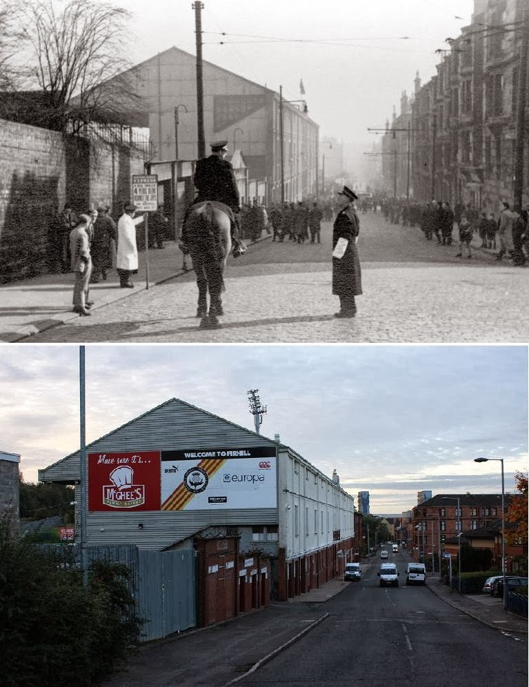
later addition to the area, arriving in their current stadium beside the Firhill Basin in 1908. In the picture below you can still see the rows of tenements opposite the stadium, all cleared away in the late 60s/ early 70s.
 |
| Looking down Firhill Road to Firhill Stadium |
From Firhill it is only 50 yards to get to Queen's Cross, home of Jaconelli's Cafe and Queen's Cross Church. This is the only church built to Charles Rennie Mackintosh's designs and is now home to the Mackintosh Society. Built in 1897, inside and out it is stunningly modern and imaginative.
 |
| Stained glass window in Queen's Cross church |
 |
| Looking up Maryhill Road at Queen's Cross |
Looking up Maryhill Road only the buildings on the right hand side of the road have survived, but if you turn around and look to the gushet at Queens Cross itself then none of the fabulous buildings in the picture below have survived. The long curving tenement in this picture was the work of another famed Glasgow architect,
Alexander 'Greek' Thomson. Built in 1875 the building comprised the two storey shop at the corner and the four storey tenement buildings down both streets. His nearest work to here still in existence are the "
Sixty Steps" at Garriochmill Road.
 |
| Queen's Cross |
The photo below is from further down Maryhill Road looking back up towards the cross when the road was lined by tenements, now long gone. Queens Cross church can be seen poking up at the top.
Further down Maryhill Road looking into Raeberry Street below you can see that the tenements down the side streets have all been demolished too. Even the church halfway down on the right was knocked down and replaced by flats a few years ago.. The shop at the left hand corner here on Maryhill Road is DM Hoey, for all your menswear needs.

At the bottom of Maryhill Road is St George's Cross, where a statue of St George and the dragon now stands. This statue used to be atop the Co-op building here and was preserved when the building was flattened in 1985. Nearby the flyover at the end of Great Western Road heads into town. It is all but impossible to picture the way this junction used to be. The old photo below has Great Western Road off to the left, Maryhill Road going off up the middle and St George's Road off to the right. Maryhill Road no longer goes up in a straight line from the cross but emerges now behind the building advertising Waddells Sausages in the old photo, which is hidden behind the tree on the right of the lower picture.
 |
| St Georges Cross |
Going back up Maryhill Road to where the fire station now is, it is surprising to look back at how well proportioned and handsome the road looked before it was decided to flatten most of this area. The block opposite in the old photo is all gone, except for the furthest away corner, another case of a pub surviving after everything else around has gone, on this occasion The Strathmore.
The next junction off to the right is Bilsland Drive, which now goes straight across into Queen Margaret Drive but at the time of the photo below you can see that the tram had to snake left to go right before the junction was re-configured.
 |
| Canal bridge on Bilsland Drive |
So finally back up to one of the oldest buildings in Maryhill, The White House pub. This opened for business in the days of the canal's construction before 1790. When I stayed across the road from here it was still open as a pub, but after lying empty for years it has recently been refurbished. Funny how it is largely the pub buildings which have survived the wrecking ball.
 |
| The White House pub at Lock 21 of the Forth and Clyde Canal |
There is no longer the same range of industries and employers in Maryhill that there was in the past. Like other areas of Glasgow it has been hamstrung by the mis-guided efforts of city planners in the 1960s and 70s. However there are new facilities being developed, such as the excellent Burgh Halls and housing improvements are clear to anyone walking along the canal today. Now all that Maryhill needs to be "wonderful" is the continued success of Partick Thistle Football Club, who remember Mary Hill in another song,
"I know a lassie, a bonnie, bonnie lassie...
...Mary fae Maryhill."
NB. I can heartily recommend that you have a rummage about in one of my favourite websites if you are still feeling nostalgic "OldGlasgowPubs.co.uk"
(These old pictures were largely found on the internet or the MItchell LIbrary. Please let me know if you feel that you hold copyright of any of these pictures as none was mentioned where I found them)